Reprofiling on Purbeck Heath

Last week I woke up in an Edwardian smallpox hospital and pulled the curtains to look out at ponies grazing on heather. This was the NT holiday cottage we lived in while reprofiling a Bronze Age Bell Barrow on Godlingston Heath.

The Isolation Hospital near the Three Barrows and Half Way Inn, Middlebere

The isolation hospital consisted of two black corrugated iron buildings surrounded by apple trees and a red phone box…. in idyllic surroundings.

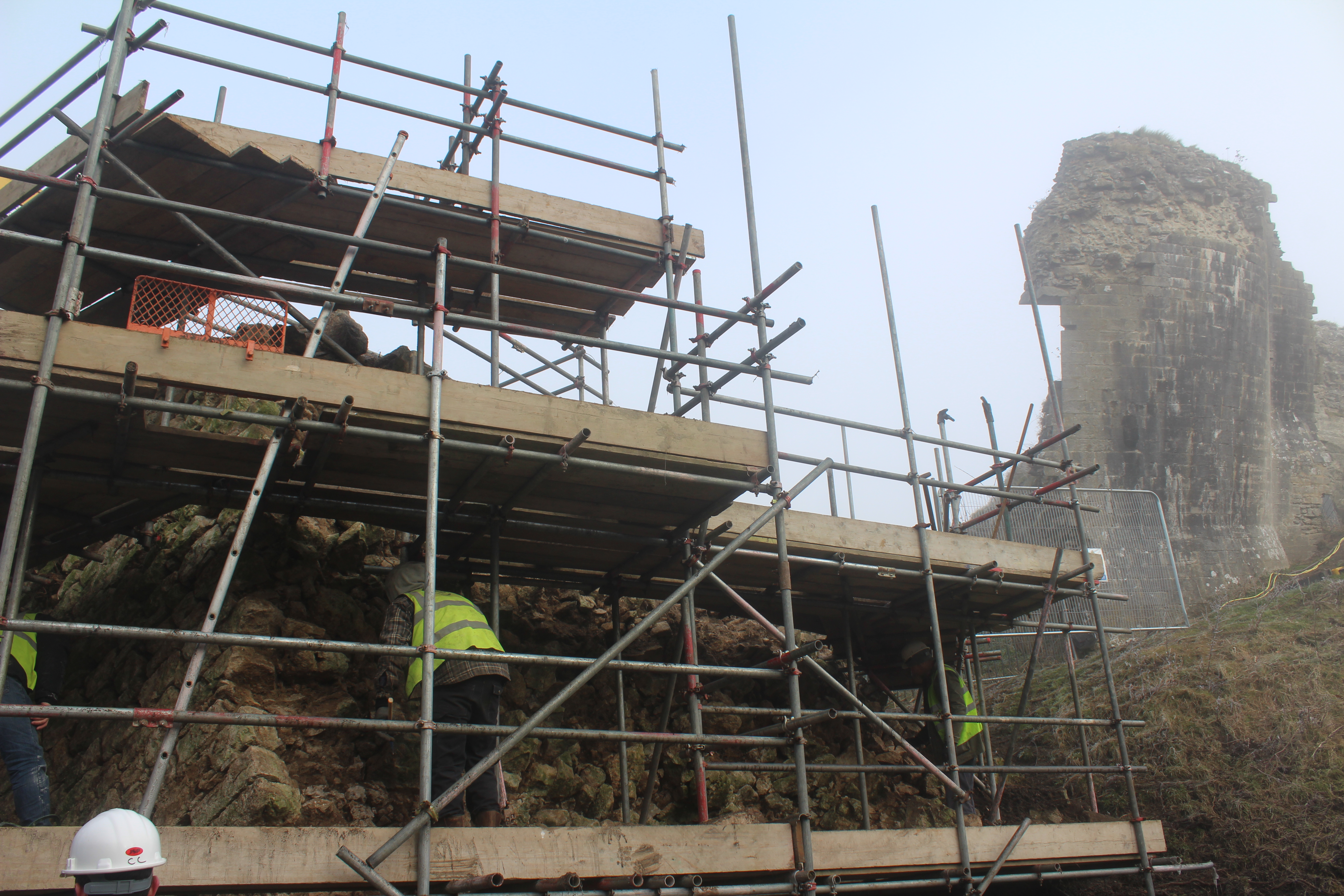
Now that the badgers had moved on and not returned for several years, our task was to redistribute the spoil from the badger setts so that the profile of the bell barrow could be restored. This would enable an even curving profile so that the monument could be covered in mesh. The work would protect the scheduled monument from any new burrowing activity.
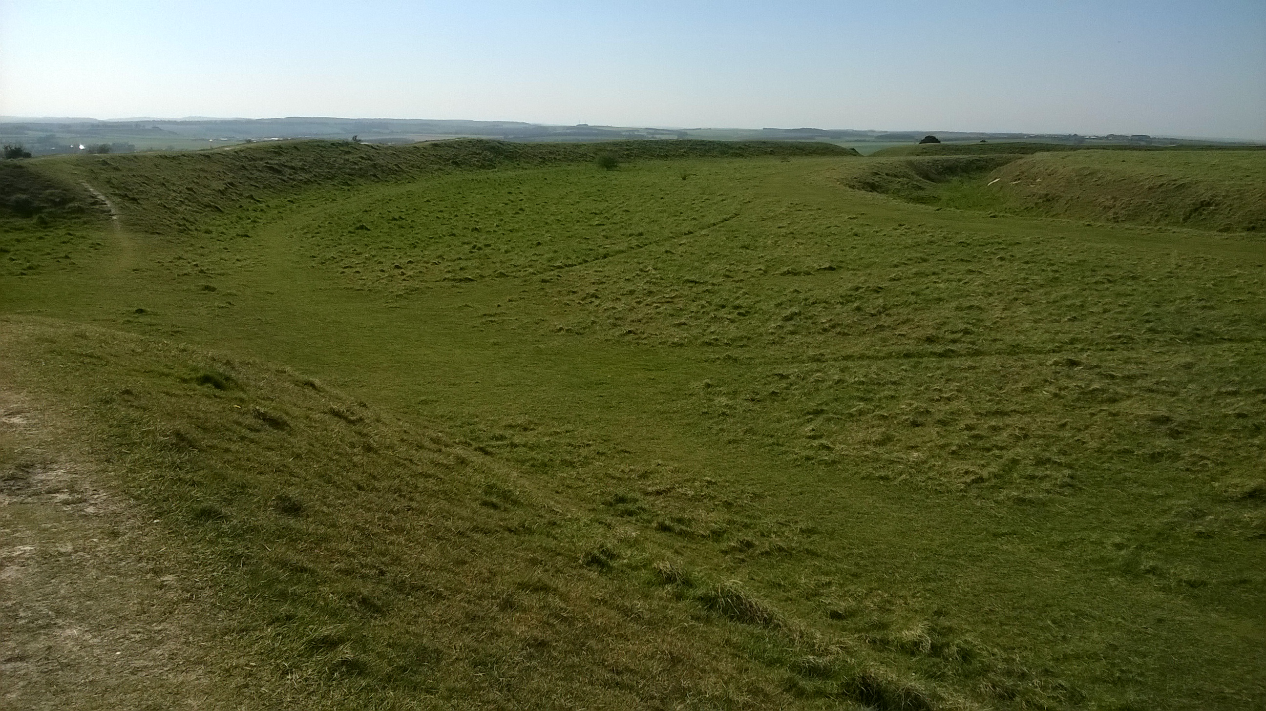
Good conservation practice… to preserve the 4,000 year old archaeological stratigraphy as a time vault against further disturbance.

Technology changes all the time and future researchers may have techniques we can only dream of… to help understand the evidence of past lives encapsulated in this place.

The short drive from the cottage took us past the ruins of Corfe Castle and along the north side of the Purbeck Hills. We arrived in a very scenic lay-by. From here there are sweeping views across heathland to Poole Harbour and Brownsea Island.

We unloaded the tools, heaved them over a fence, piled them into a wheelbarrow and pushed them downhill to the barrow. The other three barrows in this group (two other bells and a bowl) had been meshed a few years ago …but this one had been left. At that time it was too difficult because it had been so heavily dug into. We had extra Countryside Stewardship funding and could complete the work now.

The barrow from the lay-by showing the landscape towards Studland Heath and Poole Harbour

The south-west half of the barrow was in perfect condition. A very fine example of an Early Bronze Age bell barrow built c.2100-1900 BC; with its 30m diameter encircling quarry ditch, around a raised level berm 3m wide, surrounding a 2m high and 19m diameter central mound.

We soon found out why the badgers had chosen the north-east side for their home. This was the side which was sheltered …protected from the wind. We followed the badgers’ example and set up the stove and kettle here.. the best place a for tea break ..where we could admire the view.

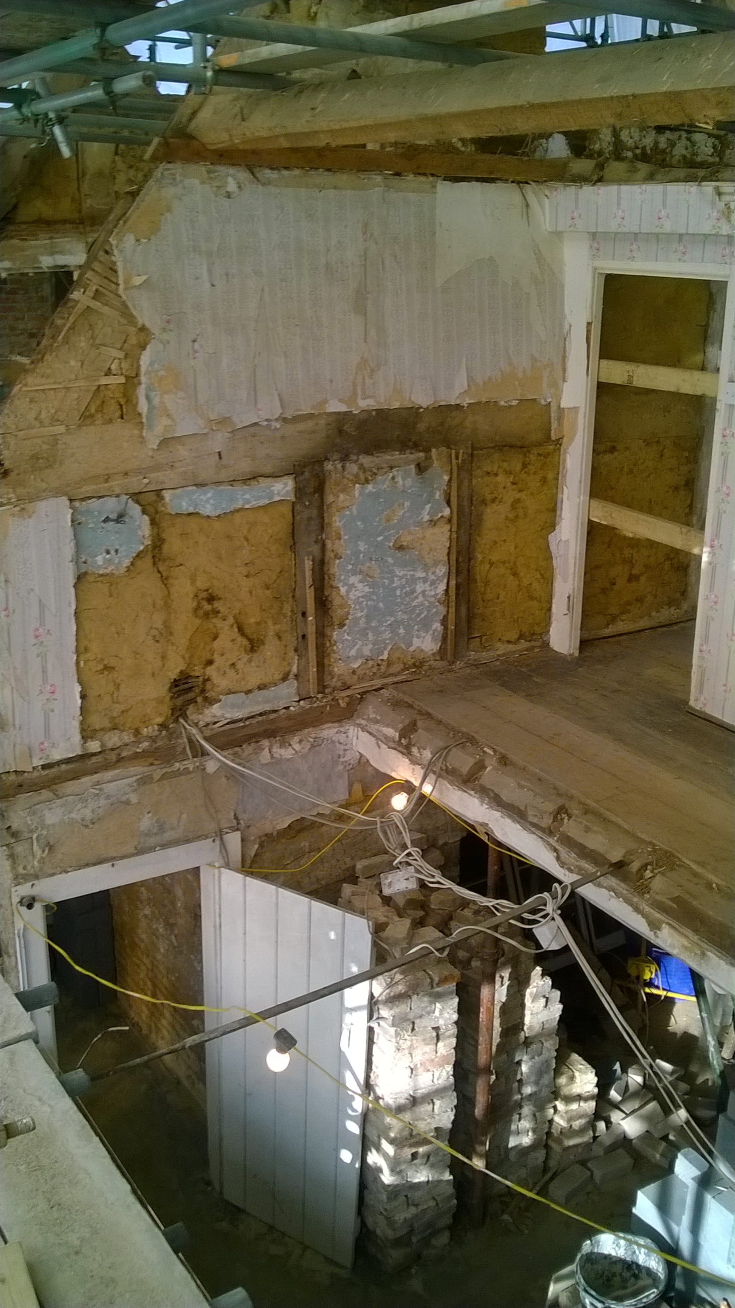
It turned out that reprofiling the site was not such a simple task…further help was needed. The now grassed over burrow heaps were full of tussocks. A hefty mattock blow merely bounced off them. Each tuft needed to be worked around, undermined and then torn from the ground. Below this was black, dry, fine sand.

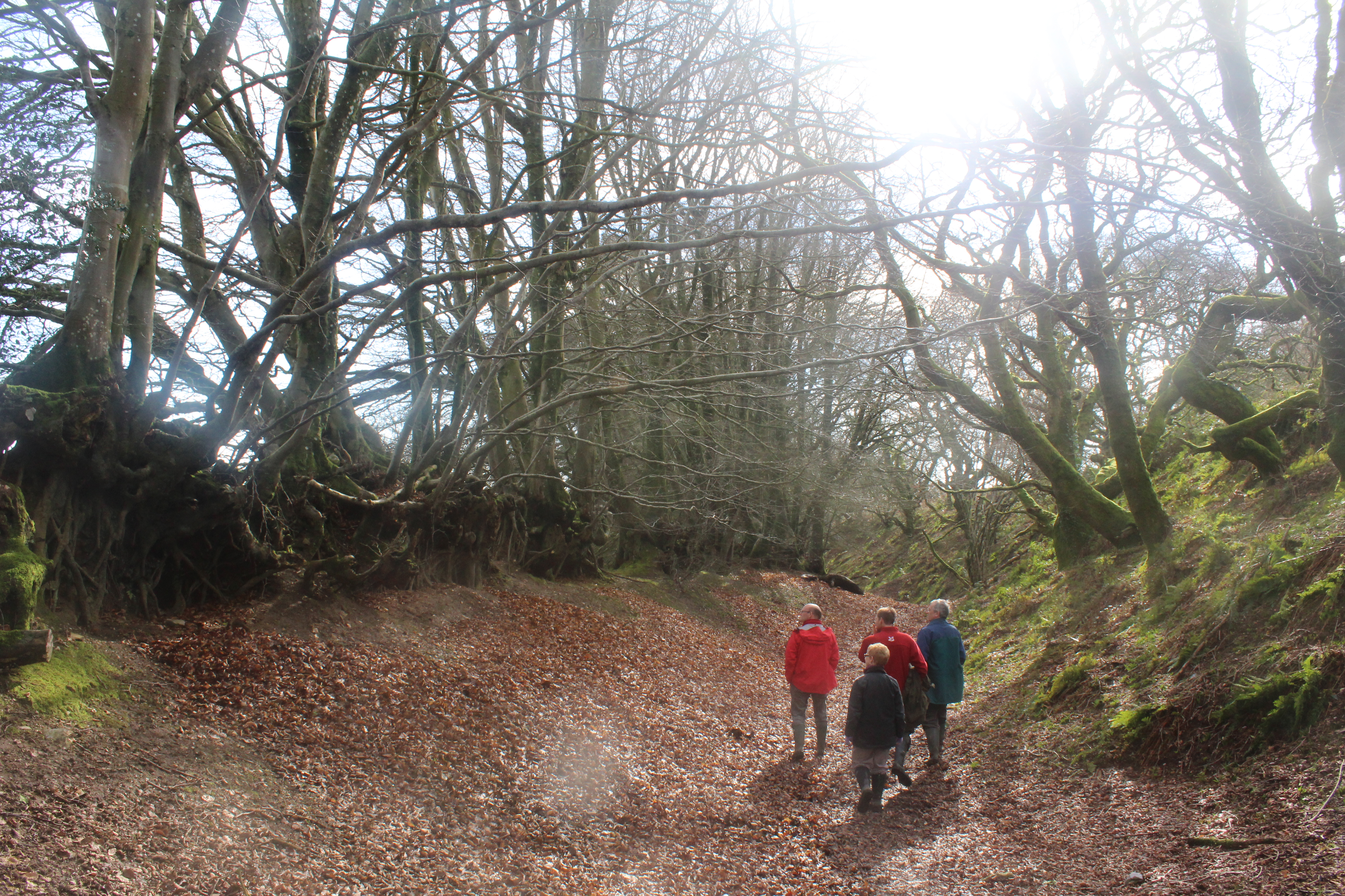
A new problem.. the constant wind whipped the sand into eyes and lungs. Nancy brought us face masks and goggles. The rangers called out the Purbeck Heritage Archaeological Rangers (HART) volunteers. Then the Wednesday group came to the rescue. We saw them park in the lay-by and approach in single file down through the bracken and gorse.

Afternoon break required a trip up to the ice-cream van in the lay-by… and the careful loading of a bucket with tubs of vanilla, rum and raisin and toffee crunch ice creams.

As the days went by… the ice cream man began to ask questions ..to discover what was going on… why did this dirty, sand-blackened man with goggle shaped clean patches rise up out of the blackberry and gorse each day?

Over time, I became less self-conscious; walking the line of lay-by cars, bucket in hand, briefly blocking the views of their occupants and trying not to catch their questioning eyes as they licked their 99s.

There was cutting the turf.. stacking it…digging the sand and re-moulding the mound… filling the buckets and carrying them to the top… where the sievers were.

A self-selected sexism evolved. The women took the buckets from the men and sieved the badger spoil…. I told tales of the Wessex Culture.. jet and amber beads… barbed and tanged flint arrowheads.. bronze daggers… the soil too acid here for bone to survive.

We found….a fragment of red plastic…just one…..not even a struck flint, just natural gravel and conglomerate red-brown Heathstone fragments. The badgers seemed not to have struck the central burial deposit and scattered the finds.

With thanks to everyone working together… our barrow achieved its proper shape and a few days later the mesh was laid. The grass and heather will grow up through the mesh and gradually it will draw it against the mound. It will take a few years to become completely hidden beneath the sward.

We carried out geophysical surveys across the whole group in 2012.

I pointed to the horizon and told the group of the six barrows I found when I first surveyed this area in 1987. Three low mounds could be seen on the hill top beyond the golf course. Nobody had spotted them before…except perhaps the soldiers training there in WWII. The mounds are punctuated by a scattered group of slit trenches dug along the ridge top in the 1940s.

The place is remote and difficult to get to. I hadn’t been there for years… but we finished early on the last day. and there was just time to take up a ranging pole and some loppers and push through the undergrowth. I crossed the stream and skirted the golf course.. stepping through marshland and then up through the heather towards my destination.

This place is so primal….when I got there, a recent heathland fire had scorched the heather and accentuated the wilderness. Somwehere… blackened and out of time.

The contours of the sweeping crescent of six barrows were very clear on the skyline… carefully designed by their ancient builders to be seen from all directions as a monument to their ancestors.

I cut some gorse stalks and took some photos..enjoyed the isolation and viewscape for a moment and turned back to civilisation.. who knows if I will come here again.


The Wessex Hillforts & Habitats Project

Early morning last week…a drone took off over Hambledon after light snow. Perfect conditions, the snowflakes had settled into the valleys of the great encircling hillfort ditches… and streets of round house platforms became visible as rows of hollows outlined in white.

Hambledon Hill light snow shows the dimples where Iron Age round houses once stood.

These photos help illustrate the majesty and awe of this vast archaeological site and has helped us launch the National Trust’s Wessex Hillforts and Habitats project. With the help of Marie, our project officer, the People’s Postcode Lottery have granted over 100,000 pounds to get the project started.

The primary purpose of the project is to enhance the conservation of 13 NT Iron Age hillforts scattered across Dorset and South Wiltshire …but it will also inspire people to get involved and to carry out monitoring and research. It will also create new interpretation to bring these grassy hill top earthworks to life as places to be appreciated, valued and better understood. Alongside this.. to highlight nature, particularly the plant and insect life. Each hillfort’s unique topography nurtures precious habitat undisturbed by agriculture for over 2000 years.

Purple spotted orchids growing on the sheltered slopes of a hillfort ditch

So.. where are these places. I’ll list them out for you…. and as some have featured in previous blog posts I’ll reference these while we have a quick tour.

We’ll start in Wiltshire and from there head south and west and eventually end at the Devon border.

Figsbury Ring, north-east of Salisbury. A circular rampart and ditch with a view back to the great cathedral spire. Strangely, Figsbury has a wide deep ditch within the hillfort ..potentially Neolithic but there is no rampart.. where did all the chalk go?

Figsbury Ring from its rampart top showing the wide deep ditch inside the hillfort.

South of Salisbury, Wick Ball Camp above Philipps House, Dinton.. NT only owns the outer rampart.

Then there is the icon of Warminster, Cley Hill (blog posts “Upon Cley Hill’; Upon Cley Hill 2”), a flying saucer shaped chalk outlier with two round barrows on the summit..a strange hillfort.

To the south west, at the source of the mighty River Stour, is the Stourhead Estate with its two hillforts. These are Park Hill Camp, its views hidden by conifer plantation and Whitesheet HillĀ  (blog Whitesheet Hill Open at the Close) with wide prospects across the Blackmore Vale towards Hambledon and Hod. We’ll follow the Stour to reach them.

Hod is the largest true hillfort in Dorset, the geophysics has shown it full of round houses…a proto town… and there are the clear earthworks of the Roman 1st century fort in Hod’s north-west corner (blog post Hod Hill Camp Bastion)

Hambledon is close by, just across a dry valley, perched high on a ridge, surrounded by the Neolithic, you feel like you’re flying when standing there. (blog post Archaeology SW day 2014, Hambledon Sunset)

Follow the Stour further south and you reach the triple ramparts and ditches of Badbury Rings on the Kingston Lacy Estate. From here you can see the chalk cliffs of the Isle of Wight (blog post Badbury and the Devil’s footprint)

Now from Badbury take the Roman road west to Dorchester and keep going beyond the county town, glancing at Maiden Castle as you pass(Duchy of Cornwall, English Heritage).

The Roman road continues straight towards Bridport but branches from the A35 road before you reach the village of Winterbourne Abbas.

It has now become a minor road.. a couple of miles on… it branches again..still straight but this once arterial Roman route to Exeter has dwindled to a narrow trackway with grass sprouting from the tarmac.

Don’t lose heart…keep going…and you will break out onto the chalkland edge and the multiple ramparts of Eggardon Hill.

From Eggardon, the other hillforts emerge as sentinals ringing the high ground overlooking the Marshwood Vale, and, to the south, the cliffs of Golden Cap.. and beyond, the sweep of Lyme Bay and the English Channel.

Winter woods at Coney’s Castle

Next to the west is Lewesdon Hill, a small fort but occupying the highest land in Dorset, nearby is the second highest, the flat top of Pilsdon Pen, surrounded by double ramparts and enclosing Iron Age round houses, Bronze Age round barrows and the pillow mounds ofĀ  the medieval rabbit warren.

The last two in the ProjectĀ guard a gap through the Upper Greensand ridge at the Devon border. Coney’s Castle has a minor road running through it and on its south side are wonderful twisted moss covered oaks… and beneath them the deep blue of bluebells in the Spring. Lambert’s Castle was used as a fair up to the mid 20th century, remains of the fair house and animal pens can be seen there ….but once again the views are spectacular, particularly in early morning after frost with the mist rising from the lowland.

Lambert’ s Castle after frost.

A baker’s dozen of hillforts of the 59 the NT looks after in the South West.

One might imagine that these huge works of humanity look after themselves… but they need to be cared for.. we must have farmers willing to graze the right number and type of stock on them….at the right times;Ā  NT rangers and volunteers to cut regenerating scrub and fix fencing and gates…

If not, these nationally important scheduled monuments and SSSIs will deteriorate. The earthworks will become overgrown and grassland habitat will be lost, archaeological knowledge locked in the layers beneath the soil will become disrupted… and the views into the landscape and across and within the hillforts will become hidden.

The Wessex Hillforts and Habitats Project promises to be an exciting time of conservation and discovery. The work has now begun!

Into Silbury Hill

I saw it once by moonlight. Returning on the Marlborough Road, in the dark, surrounded by the silver-washed, gently curving chalkland. Then dreaming..forgetting…and a little before the Avebury turning… it reared up from the right, huge and impossible. Surely too big to be made, a conical flat-topped mass. A passing Neolithic shock.

IMG_9895

I remembered 1968, my mum calling me to the TV. Live archaeology and Professor Atkinson driving his tunnel to the centre. I had no idea what Silbury was then. I never saw it until I was 18.

Then in the 90s, after moving to Wiltshire, sitting in Devizes Museum at the WAC meeting. At the end, we drank coffee and Gill and Andrew said: ‘yes, we were there with Atkinson.We walked with him to the centre’. Wow! What a thing!

The National Trust have never owned Silbury but have managed it as part of their Avebury Estate.

In May 2000, we were excavating the Lacock Rockworks. Rosie, the Avebury archaeologist ranger, arrived late. She had been called to the top of Silbury with Chris, the NT property manager. ‘There’s a hole!’ she said, ‘a vertical shaft right down to the centre of Silbury’.

English Heritage fenced it off and considered the options. The Hill was not as stable as might be imagined.

For many generations visitors had wondered. Was this the tomb of a great king? Something so huge had surely been raised in honour of someone exceptional and his grave must be furnished with fabulous treasure. So, in 1776, Edward Drax, with some support from Hugh Percy duke of Northumberland, directed a group of miners to sink a vertical shaft to the centre. They were disappointed, no tomb was found. Silbury was further disturbed in 1849, by Rev John Merewether, who organised the digging of a new horizontal tunnel, no finds for him either except his report of preserved organic remains near the centre. Then a pause for a century plus and Professor Atkinson, famed for his work at Stonehenge, directed the campaign I had seen on TV as a child. Another horizontal tunnel with branches.

The experts shook their heads. Something must be done. A conference was called and the players assembled at Devizes Corn Exchange. I sat and heard the debate and remembered Professor Bradley strongly advocating the solution. Reopen Atkinson’s shaft, assemble a crack team and employ the very best archaeological techniques that the 21st century can offer. Create a new exceptional record and then backfill with packed chalk…and seal for all time.

And so it came to pass. The tunnel was opened, the section through the hill was scanned, drawn and photographed in great detail. Samples were taken and analysed…..and then, the invitations went out.

RIMG0032

In the autumn of 2007, we assembled at the portacabins for the health and safety talk. David Attenborough, almost 40 years later, had just returned again from the centre… and now it was our turn.

Along a track…Silbury looming over us…we circled the perimeter of the artificial mountain, to arrive at a concrete portal at its base. The worn green door had a futuristic S on the front, not superman.. Silbury of course, and above it on the lintel ..1968.

RIMG0034

Jim Leary, the English Heritage site director, gave an introductory talk on the threshold,…then the door was opened and we were allowed to enter. ‘we few, we happy few’.

A line of steel ‘U’ frames ran into the distance illuminated by rigged strip lights a network of wires and ribbed ventilation tubing but amongst it all and between the frames the stratigraphy of the mound. ‘Here is the trampled chalk’ Jim pointed. The ancients had worked here compressing the chalk rubble with their feet as they built their mountain.

Further in and the frames were bent and twisted. The torch illuminated a void sloping upwards. Was this where Professor Atkinson cut Rev Merewether’s tunnel?

RIMG0051

Deep below the mound and far from the entrance, the white chalk walls turned brown. We had crossed the inner ditch and here were the beginnings of the construction. Silbury had been built in successive phases but the C14 dates tell us that all the work took place over a short period, c.2400-2300 BC. They started small, heaping gravel from the nearby river and then cutting the turf and topsoil and heaping it into a mound.

RIMG0056

We reached the far end and here was the treasure where we stopped. The famous turf stack where the 1960s diggers had told their stories of green grass and beetles’ wings. Extraordinary environmental survival, sealed within the earth. Many more samples were taken and the list of plants and invertebrates grew and told of a landscape of chalkland pasture. Though we do not know the exact year, the insects tell us that this organised and presumably vast community of farmers cut this turf in the summer. Some of the creatures that were found, only emerge from their larvae in August.

RIMG0060

They didn’t stop. They kept building. What drove them on? They dug deep into the chalk creating a massive moat that Ā still fills with water after heavy rain in winter. They heaped the chalk higher and higher. A monument to the very end of the Neolithic..as if to say. ‘See! This is what we can do with bone and wood and stone’. That was before the strangers came with their clever rocks from far away. Rocks that could be melted and mixed and beaten to create sharp blades and shiny ornaments.

RIMG0087

Nancy and I retraced our steps, back down the tunnel and out into the light. Best to go to the Avebury Henge, to walk beside the megaliths and then to take tea in the Stones restaurant beside the tithe barn.

To savour the electricity of the moment.

Under the First Tower Corfe Castle

dcoc612

Sometimes, at a distance, when the sunlight hits Corfe Castle… it seems whole again..

Just an illusion..it has been a battered shell since 1646, when, after a long siege, it was captured and blown apart by the Parliamentarians.

They made sure that the supporters of King Charles could not use it again..unpicking the defenses, trenching under the walls, packing with gunpowder and throwing the turrets and walls in all directions.

But this blog is also about something that happened 300 years earlier ..when Corfe Castle was one of the brightest and best within the league table of medieval fortresses.

About 1250, the 1st Tower was created for King Henry III.

When first added to the defensive circuit, this structure was a cutting edge design, built to protect the southern and western approaches. The barons were often restless.

A wonderful thing, with its rounded tower and its 3 arrow loop embrasures.. from these, bowmen or more probably cross bowmen could take aim and fell an attacker up to 300m away. A crossbow bolt could penetrate a knight’s armour.

We only know of one illustration and then only in plan.. drawn for the new owner Sir Christoper Hatton..14 years after it was sold to him by Elizabeth I. Such castles were old fashioned by then.

1st-tower-treswell

Ralph Treswell’s 1586 survey of Corfe Castle shows the 1st Tower between the steps up to the Outer Gatehouse (right) and the Outer Bailey latrines (left). 60 years later it was blown in two.

The Parliamentary demolition team searched for weak spots and made them weaker. They set their charges and the explosion fractured the 1st tower.. right down its central arrowloop. It must have sounded like an earthquake in the town.. and when the dust settled, the east half leaned drunkenly outward and the west half Ā had been flipped 180 degrees coming to a rest half way down the hill slope.. This is where it has remained gathering soil, vegetation and scrub for another 371 years.

dcoc591

Looking along the west wall of the Outer Bailey from the SW Gatehouse towards Corfe Village. The scrub covered fallen 1st Tower lies below the castle wall hidden by vegetation directly below the position of the church tower.

Other parts of the Castle have been cleaned and consolidated over the years but the chunks that lie tumbled across the slopes, or down by the river, have not. The largest of these pieces is the First Tower, and now …the scaffolding is upon it.

So last week I headed south through a cold winter morning of dramatic contrasts: on the high chalk downs, bright melting sunlight above vales of mist.. but down on the heath, thick freezing fog and brittle white frosted trees.

The caged Tower loomed but nobody was on it. I found them in the tea rooms beside the Outer Bridge. Architects, builders and property staff… after warm drinks we headed for the vertical ladder up from the ditch.

img_5980

The route up to the First Tower from the Castle Ditch. The standing half of the tower is on the right with part of the 13th century cross-loop visible, the other half is part buried beneath the lowest scaffolding.

A good time to visit. Most of the centuries of roots and soil had been removed. We climbed over the scaffolding and saw, up close, the medieval construction, types of mortar, the galleting of the joints and the different beds of Purbeck stone, the arrangement of rubble and fine ashlar.

img_5982

But everything in reverse. When we got to the top, we saw the great slabs of Purbeck Marble laid down as foundation layers before the tower proper was built above. Someone saw tool marks around their edges and suggested they may have been recycled coffin cover rough-outs.

img_5997

The foundation of the Tower made of large long slabs of stone, then rough block work, not meant to be seen, followed by the finely worked ashlar burr stone forming the battered plinth (three course vertical, three at 60 degrees and then vertical again rising to the top of the rounded tower).

A stranded whale of a thing, its construction now more visible than at any time since it was built.

Could we laser scan it and capture this revelation in time?

Yes it can be done.

It will be partly obscured soon, new mortar and capping needs to be placed over the Tower to protect the newly exposed structure from weathering.

Both halves will be digitised.

The scaffolding will be edited out, and then, by the touch of a button… the First Tower will be reunited again.

IMG_5973.JPG

Ā 


Boundaries & Hedges: Look Deeper

Look into this photo…look deep into this photo.

What do you see?

Kingston Lacy NT403 4 Feb 1989

Yes, I know.. it’s just a bit of farmland.

Look deeper…there’s at least 4000 years of farmland here.
Look at the hedgerows….they’re very precious …on a European scale, our bushy boundaries are surprisingly rare and wonderful for wildlife.

Off to the left is the edge of Badbury Rings.. so we’re on the Kingston Lacy Estate in Dorset again.

Kingston Lacy for me is like Miss Marple’s village.

We are on the south side of the grand Beech Avenue. William John Bankes had this planted for his mother in 1835.

This land has been ploughed for many generations. Bottom centre, there’s a dark circle with a black blob in it.

The ploughing has levelled an Early Bronze Age burial mound and all that is left is the cut of the quarry ditch. From here the chalk was dug to heap up the bright white mound over the grave. Perhaps the body is still in the grave pit marked by the blob.

The Round Barrow was once an eye-catcher. About 1000BC the land was divided into units by linear boundary ditches. Perhaps population was rising. Boundaries needed to be clear and well defined. The barrow mound formed a good fixed point and the boundary runs against it.

Look again. This linear boundary does not follow a straight line. It has to weave between existing fields. Can you see the white ghost lines of the chalk field banks it has to negotiate. These are small ‘celtic’ fields, in use from the Bronze Age through to the Roman period and later.

Many hedge and wall field systems in the west still follow boundaries as old as this.

Nothing is completely static.

Look up to the centre right and see a group of dark-lined enclosure ditches overlying the ghosts. I walked there with the farmer once and recovered scraps of Roman pottery from the new ploughed field. Stock enclosures, Roman development over part of the old system.

Zoom out a little… can you see broad bands of darker and lighter stripes running roughly with the hedgerows?..

These are the remains of the furlongs and strips of Shapwick’s common arable field system. A time of centralisation when scattered farmsteads and fields became concentrated. Devised by the Saxons, around the 10th century, communities farmed their scattered strips within the great fields, managed by the lord’s manorial court.

At Kingston Lacy, this system continued right down to the 19th century. We have a great map showing all the strip fields in 1773-4, it tells us who farmed what.The small guys were being squeezed out by the larger farmers.

How old fashioned! This was the advice of William Woodward, the surveyor, who advised the Bankes family to enclose the land. In 1813, a new map was made and the land was divided up into large economic farms with straight hedge boundaries. The smallholders became farm labourers.

Kingston Lacy 39007 Aug. 1994

Look into this photograph. Look deep into this photograph. We are east of Badbury now. Towards Kingston Lacy Park.

Bottom left is the tree-edged enclosure of Lodge Farm. All the names in the landscape matter. It’s ‘lodge’ after the medieval hunting lodge.

The stone lodge itself now has a lawn in front of it. A 15th century building on the site of an earlier building at the gateway to the royal deer park and warren of Badbury. This park is documented right back to Henry de Lacy’s time in the 13th century.

Top, right of Badbury, is the medieval High Wood, and middle right is a hedgerow strip marking the deep survival of the broad medieval deer park ditch. Designed for fallow deer to leap in but not get out. Deer were valued for their high status meat, a preserve of the rich carefully nurtured and guarded.

Badbury Warren was maintained right up to bachelor John Bankes’ day. There were complaints that the thousands of rabbits kept there, got out into the corn and coppices and damaged the crops.

John’s mum Margaret always kept the accounts and when John took over the Estate he followed her example….right up to 1740, when he closed the account book and left a few sheets of paper there.

One of these contained the inked in costs of enclosing the Warren. All the hedges in this photo were planted at this time. Their names give away the old use of this new farmland…’Lodge Field’, ‘Deer Hill Field’, ‘Hare Run Field’ and ..

‘Watch House Field’ (watching for poachers? a dangerous job, one of the medieval keepers Henry Warren was murdered…)

Sometimes… in the right conditions…. the Roman road from Poole on the coast to Badbury can be seen running from Lodge Farm across the fields.. aiming for the saddle of land between the hills of Badbury and High Wood.

Not in this photograph though..

each year brings new conditions of ploughing, drought, snow and frost and …new revelations of the past become possible…

Kingston Lacy 39017 Aug. 1994

Look into this photograph…north of Badbury now…what can you see?

The spaghetti junction of Roman Dorset! We’re looking down the barrel of the late 4th century road from Old Sarum (Salisbury), the London Road, to the civitas captital of Dorchester (still Dorset’s county town).

This late road crosses two, perhaps three earlier roads. The Poole road turns in the middle leftĀ of the photoĀ and splits.

First joining the field boundary running to bottom centre (the road to London).

Second crossing the centre of the field, under the Dorchester road, and continuing to Bath and….

Third.. following the straight, thick hedge boundary between Badbury and the arable fields. Another road, long forgotten, heading for the Somerset Roman town of Ilchester.

This boundary, preserved and managed over the centuries.. ancient, ancient boundary held in the landscape as a hedge…once a Roman road.. it became a convenient straight marker in the 12th century to divide off Ā the new manor of Shapwick from the royal manor of Wimborne Minster…

and today it remains the parish boundary between the St Batholomew’s Church of Shapwick Ā and St Stephen’s of Pamphill.

Everything in the landscape speaks. Ancient public footpaths, names of fields, woodlands, coppices…all Ā full of stories and ….hedgerows are particularly precious and vulnerable…


Solsbury Hill and the Bath Skyline

Climbing up on Solsbury Hill
I could see the city light
Wind was blowing, time stood still
Eagle flew out of the night…. Peter Gabriel 1978

Solsbury Hill on the north-east side of the World Heritage City of Bath may be particularly famous for this songĀ (if you’re a Peter Gabriel and Genesis fan) but my job this week has been to write about its archaeology.

The NT are commissioning new guide books and Brean Down and Bath Skyline are on the go at the moment.

This land does what it says in the property title. It occupies the skyline to south, east and north of the city and has been acquired bit by bit over the years. It enables the National Trust to buffer development on the high ground and conserve views to and from Bath.

The view from the front o Ralph Allen's 18th century Neo-classical house looking north-west across is designed parkland landscape towards the city of Bath. The palladian bridge over the lakes can be seen in the middle distance

The view from the front of Ralph Allen’s 18th century Neo-Classical house looking north-west across its designed parkland landscape towards the city of Bath. The palladian bridge over the lakes can be seen in the middle distance

Anyway here is the draft for the guidebook. This bit gives a bit of an overview..

In the minds of our ancestors, Bath would appear as a rare, wonderful and magical place where hot water issued from the ground.

No wonder the god of the spring required worship, and prehistoric objects including Iron Age coins were cast into the hot water long before the Romans arrived. After the Conquest, the Romans created a monumental shrine complex to worship the celtic god Sulis which was then partnered with the Roman god Minerva. This place became a site of pilgrimage from far and wide.

The surrounding landscape had light limestone soils and were a magnet for early farmers; ideal for early cultivation using the primitive ploughs of the time. When the Romans arrived, they saw the qualities of the easily worked local beds of Bath freestone. The Saxons were less inclined to build in stone but Bath boasts great stone buildings from the medieval period to the present day. In the mid 18th century, Ralph Allen recognised the qualities of Bath stone and marketed it by building the great house and designed landscape of Prior Park as his shop window.

View of Ralph Allan's great house looking south from the middle lake of the designed landscape.

View of Ralph Allen’s great house looking south from the middle lake of the designed landscape with the palladian bridge in the foreground.

He helped develop the Georgian city which gives the place its World Heritage Site Status today.

There’s a bit about Bushey Norwood which has the earthworks of a prehistoric farm and a bit on Bathwick and Rainbow Wood once part of the Bishop of Bath’s deer park where the remains of Roman buildings survive.

Bushey Norwood prehistoric field system looking south west towards Bath

Bushey Norwood prehistoric field system looking south-west towards Bath

The main bit is on Solsbury Hill….

This is a stunning location, an ideal place to build an Iron Age hillfort.

Many centuries later, its abandoned earthworks were adapted into a medieval strip farming system. These narrow fields were marked by mere stones, each engraved with an allotment holderā€™s initials.

People have visited this place for thousands of years: stray finds dating to the later Neolithic (2600-2300 BC) and Bronze Age (2300-700BC) demonstrate this; but the key feature is the 8 hectare (18 acre) hillfort, a defended settlement occupied over 2000 years ago. A visit to Solsbury Hill will help you appreciate its strategic position overlooking the Avon valley: a near level hill-top protected by steep slopes with clear views in all directions.

Two pieces of archaeological work: one very recent and the other over 50 years old, help us to imagine the lives of the families that once lived on Solsbury.

Excavations from 1955-1958 revealed that the hill-top was surrounded by a carefully constructed stone faced rampart with an entrance on the north-west side. Within this was evidence for the warrior farmer community which once occupied this place. Their homes were round houses, each constructed of a ring of timber posts infilled with mud and woven branches with a thatched conical roof.

In 2012, a geophysical survey of the interior by the Bath and Camerton Archaeological Society, revealed the sites of over 50 round houses. These homes and store buildings show up clearly on the survey plan because each was surrounded by a distinctive circular drainage ditch.

The 1950s digs showed that the earliest houses were built before the hill-top was defended. Then the first rampart was built and then pulled down… perhaps after an attack. Then another wall was constructed but this time associated with a new form of pottery.

Does this suggest invaders and if so what happened to the original Solsbury dwellers? But perhaps they never left; just bought some more fashionable pottery and rebuilt their defences (the marvelous vagueness of archaeological evidence).

The dig director was W.A. Dowden of the Bristol University Spelaeological Society. He looked at the cooking pot fragments found in his trenches and concluded that the fort settlement had been occupied in the middle Iron Age c.300BC and had been abandoned at least 100 years before the Roman army conquered the area c.AD44.

The excavation revealed the farm produce from the surrounding countryside: quern stones, once used to grind the harvested grain into flour and the meat bones of their grazing animals; domestic cattle and sheep.

A bridle bit demonstrated that the wealthier occupants rode horses; two decorated weaving combs were a reminder that clothing was made here and two spearheads and sling stones demonstrated that the inhabitants were armed and ready to defend their homes.

Solsbury Hill Iron Age hillfort looking south-west towards Bath. The earthworks of the medieval and later strip farming system can be seen as earthworks hiding the earlier round houses.

Solsbury Hill Iron Age hillfort looking south-west towards Bath. The earthworks of the medieval and later strip farming system can be seen as earthworks hiding the earlier round houses.

As you stand on the hill top, imagine it crowded with Iron Age round houses and people, then sweep them away and see the ridges of long strip fields with medieval farmers trudging up and down behind ox teams, ploughing the settlement ruins buried below.

It still needs some editing… but next time you go to Bath, visit the Skyline and enjoy the archaeology and views of the City.

Lodge Park Grandstand, Behind the Blocked Door

Lodge Park in Gloucestershire was where the last Lord Sherborne lived before he bequeathed his Sherborne Estate to the National Trust in 1982.

It wasn’t originally meant to be a home but a place to go with your mates. It was an ornamental grandstand built in the 1630s by the then owner John Dutton. A posh place to drink and bet on the deer selected from the adjoining park. The deer were sent down a walled corridor of land, chased by hounds across the front of this unique building. The assembly then probably got drunk and had venison for tea.

Lodge Park on the Sherborne Estate, Gloucestershire. This is John Dutton's grandstand where he and his mates could spend boozy afternoons betting on deer chased by hounds across the front of the building. About a century later the park behind the house was transformed into an avenued designed landscape by Charles Bridgeman. Our excavations were on the left (west) side of the building.

Lodge Park on the Sherborne Estate, Gloucestershire. This is John Dutton’s grandstand where he and his mates could spend boozy afternoons betting on deer chased by hounds across the front of the building. About a century later the park behind the house was transformed into an avenued designed landscape by Charles Bridgeman. Our excavations were on the left (west) side of the building.

The park is full of earthworks including the best preserved Gloucestershire long barrow and the earthworks of the strip fields of open field systems. Three parishes meet at a point just behind the Lodge and it was here in the 1720s that Charles Bridgeman chose the key outlook point for his innovative garden landscape design. A segway between earlier formal and later Capability type landscapes. Highly significant and we have his drawn plan. Was it ever completed? Did it work? Should NT redo it? Lots of discussions but that’s not the point of this blog.

We’ve discovered something new.

The stairs down to the 17th century basement kitchen infilled about 100 years ago and dug out again in the 1990s when Lodge Park was restored.

The stairs down to the 17th century basement kitchen infilled about 100 years ago and dug out again in the 1990s when Lodge Park was restored.

Back in the 1990s the NT took out the later additions and divisions within the Lodge Park Grandstand to return it to its 1630s form. The cellar had been backfilled about 100 years ago and this was dug out again to reveal the 1630s kitchens where John Dutton’s feasts were cooked. The cellar had vents put into it 20 years ago but despite this has always been damp wih mould growing off the walls and floors. Bit unpleasant.

One solution was to open the blocked door. In the 90s the discovery of the blocked door led to the suggestion that there had once been an external flight of stairs, a tradesman’s entrance where perhaps the venison and other food stuffs could be brought into the kitchen. So..find the stairs, uncover them, unblock the door, new access and extra ventilation…. damp problem solved.

November 2015 looking for the external stairway into the basement. No trace. We need a machine.

November 2015 looking for the external stairway into the basement. No trace. We need a machine.

So in November building surveyor Christina asked Jim and I to turn up with shovels and mattocks to look for the top step of the cellar stairway. On the most likely north side of the blocked door our hole just found modern service pipes. So we dug beneath flagstones on the south side nothing… the ground here seemed to be natural about 30cm down. We gave up and vowed to return with a machine.

The mysterious blocked door in the cellar. The ranging pole divisions are 0.2m and at 1.7m up you can see that the doorway and blocking has been removed and the wall rebuilt in the 19th century. Note the vent top right can be seen in the next photo outside to the left of the mini-digger.

The mysterious blocked door in the cellar. The ranging pole divisions are 0.2m and at 1.7m up you can see that the doorway and blocking has been removed and the wall rebuilt in the 19th century. Note the vent top right can be seen in the next photo outside to the left of the mini-digger.

A few weeks ago Jim brought his mini-digger. This time we aimed for the centre of the west side of the Lodge immediately above the blocked door. More reduntant drainage pipes and then clay and then… solid stone and mortar about 0.6m down. I jumped into the trench and cleaned back its gently arched top. There was a gap between the Lodge wall and the newly discovered structure. It was where the wall had been rebuilt about 100 years ago.

Mini-digger digs down to find the blocked door.

Mini-digger digs down to find the blocked door.

I took part of the filling from the gap and found that I could put my hand into a void under the structure. I was sitting on the roof of a vaulted chamber. I got a ranging pole and slid it into the gap and then swung it round into the void. It fell away. Only the front end was filled with spoil.

Solid stone and mortar roof of the vault cut by the rebuilding of the Lodge annex in the 19th century. We slid the ranging pole between the gap an waved it around in the empty space which is the hidden room or passage heading west...

Solid stone and mortar roof of the vault cut by the rebuilding of the Lodge annex in the 19th century. We slid the ranging pole between the gap and waved it around in the empty space which is the hidden room or passage heading west…

We speculated…is it a tunnel and where does it go? or is it just a hidden chamber. Jim reckoned it might lead to slaughter barn where the deer are supposed to have been dispatched before being brought to the Grandstand..

A mystery…I wonder whether we should unblock the door.

EH 2005 interpretation plan

A plan of Lodge Park carried out by English Heritage 2005. It shows the earthworks across the park which include medieval ridge and furrow, parish boundaries as well as tree planting holes part of the designed avenues of trees planted by the famous landscape designer Charles Bridgeman in the mid 18th century.

Open the door

The north side of Kingston Lacy House. Designed by Roger Pratt for Ralph Bankes in the 1660s. Revamped for Henry Bankes by Brettingham in the late 18th century and then done over again by Charles Barry for William John Bankes in the early 19th century.

The north side of Kingston Lacy House. Designed by Roger Pratt for Ralph Bankes in the 1660s. Revamped for Henry Bankes by Brettingham in the late 18th century and then done over again by Charles Barry for William John Bankes in the early 19th century.

We often get called in to check everyday repair work inside our great mansions, electric cabling, loose flagstones or finding where water is getting into the building. This kind of watching brief (monitor and record) gives us a chance to look beneath floorboards and behind paneling, it provides an opportunity to see how the buildings were put together and more importantly any changes done through time.

At Kingston Lacy wiring and ceiling checks are being done in some of the rooms with just a few floorboards being lifted. Having foundĀ scraps of Ā originalĀ wallpapers and notes left by previous workmen during work like this in the past we were called in to record anything we could see.

Floorboards lifted in the Saloon at Kingston Lacy

Floorboards lifted in the Saloon at Kingston Lacy

In the saloon we found that a lot of the material between the joists had been removed in the past with just a few wood shavings and the odd nail left behind. The most interesting areas were accessible via the doorway, with just enough room to dangle my camera into the void and between the joists. I set it toĀ do 10 shots on the self timer setting and hoped for the best. This technique is a good way to see down and along voids, it had produced good results in the past at Chedworth roman villa when checking for hypocausts and wall alignments.

View along the hypocaust at Chedworth Villa in room 5b

View along the hypocaust at Chedworth Villa in room 5b

We were not disappointed an odd metal concertina likeĀ heating system, a large vaulted void, Pratt bricks from theĀ original mansion, (now encased inĀ stone)Ā and an intriguing door mechanism.

The metal heating system on the left

The metal heating system on the left

A vaulted ceiling of a room below the Saloon at Kingston Lacy, the plaster can be seen oozing between the lathes

A vaulted ceiling of a room below the Saloon at Kingston Lacy, the plaster can be seen oozing between the lathes


Two metal bars part of a cleaver mechanism

Two metal bars part of a cleaver mechanism

The Saloon is entered and connected to other rooms Ā by double doors, the lifting of the floor boards revealed how they opened exactly together, even when just pushing gently on only one door. This would help servants when carrying trays open the doors without putting the tray down or needing someone to help them, also when entering or exiting the room with swishing skirts ladies could move effortlessly through the doorways.

It works by using what look like bicycle chains and smooth cogs, a simple but effective mechanism.

The chain and smooth cog, with a metal rod up into the door

The chain and smooth cog, with a metal rod up into the door

There are more planned surveys to be done at Kingston Lacy in other rooms, I wonder what awaits to be found under the next floorboard………….


Sherborne’s Romans: Under the Stubble

On Monday I had a meeting in Bristol but I really wanted to be in Sherborne Gloucestershire.

After several years of fieldwalking and geophysical survey, the time had arrived to test the ground and see if anything survived beneath the wheat stubble on Woeful Lake Farm. The survey plots showed rectilinear patterns across the fields, surely there were still building remains, enclosure ditches and other features…under the soil.

These fields had been ploughed for 100s of years and this vital process of producing food had gradually dug into, turned and jumbled the ground many, many times.. eroding away the archaeology.

Ann, Tony and other members Gloucestershire Archaeology had put in three small trenches over the weekend and they needed to be backfilled to enable the farmer to plant his next crop.

So, when the Bristol meeting was over, Ā I scooted up the M5 and across the Cotswolds via Crickley Hill and reached the field… to see everyone poised with shovels and spades. The ring of tea break chairs and a survey tripod silhouetted against the skyline…

IMG_3518

The excavation trenches on the skyline poised to be backfilled.

but I had arrived in time, the piles of spoil still stood beside the trenches and I was able to see what had been found.

One trench had come down onto an 0.8m wide limestone wall. The geophysical survey plot indicated that it should turn a corner in the next small trench but there was only the rubble foundation surviving there. The wall courses had been ploughed away.

IMG_3489

The newly unearthed Roman wall survives two courses deep on a rubble foundation just beneath the ploughsoil.

The best finds came from the trench about 15m further across the field. Here, a mint condition silver coin had been found. It lay where it had been dropped 1700 years ago on the surface of a rough limestone floor.

IMG_3505

The coin of Marcus Claudius Tacitus.. Emperor for 200 days Ā September 275- June 276

The name Tacitus could still be read around the head of the Emperor with his typical 3rd century spiky crown (barbarate radiate).

Later, I looked him up. He wasn’t a bad emperor and seemed to be sorting things out but only reigned 200 days. The jury is out, one source states that he died of a fever but he may well have been assassinated. These were unsettled times.

A pit had been cut through the limestone floor and within the dark soil filling was found a bronze brooch. This one was in very good condition and still had the pin to enable you to hold your cloak in place.

Capture

Ann’s brooch from the pit. Bit of a clean up and it’s almost good enough to wear.

The pottery and other finds from the trenches showed that people had been living here from the 2nd-4th century.

I took some photos and thanked everyone for holding back until I could see their discoveries. Further deep ploughing would quickly damage the shallow buried remains but minimum tillage saves on agricultural fuel and preserves archaeology below the old ploughsoil depth.

These are just small window trenches. Perhaps we will return next year to see more of this Roman settlement at the head of a small valley just a few miles from Chedworth Roman Villa. There are many more acres to cover with geophysical survey before we have an idea of the extent of this place.

I wonder how many people lived here and what place name they had for their home.

IMG_3523

The earthwork remains of the Roman amphitheatreĀ at Corinium Dubunnorum, a few miles down the Fosse Way from Sherborne. The tiers of wooden seats surrounding the floor of the auditorium have long gone .. as have the cheering and jeering local crowds who once watched the entertainment.

The Cotswolds had a high population in the Roman period. Their main town would have been Corinium, the second largest place in Roman Britain. We call it Cirencester today…I drove through the town on the way home and stopped off to look at the abandoned Ā earthworks of its amphitheatre.

Perhaps the owner of the newly rediscovered brooch once visited here to see a show….


Hearth & Home 545 Kingston Lacy

Buildings archaeology tends to be less straightforward than dirt archaeology. Standing structures in 3D are not sealed beneath the ground. You have to work out whether the thing you are uncovering is an original piece of the building, in its right place, or part of an older building moved and recycled from somewhere else.

Fireplaces are good evidence. Usually the massive inglenook fireplace has been infilled by a nest of smaller and smaller fireplaces as fashions, usage and the technology of heating changed. These days it’s all the rage to open up and expose the original large fireplace again and this unseals evidence of the everyday lives of the families who lived there centuries before.

The centre of a building is the hearth. It’s where the warmth is. Where the meals are cooked. The 4500 year old Neolithic houses recently found at Durrington on the Stonehenge Estate had hearths at their centres.

RIMG0236

The dark circle in the middle of the white rectangle is the hearth in the centre of the 4500 year old house excavated at Durrington Walls in 2007

The ordinary medieval cottages at Kingston Lacy would have had open hearths with the smoke seeping out through the thatch, but by the 16th century some would have had two closely set roof trusses to catch the smoke and direct it out through a vent ( a smoke bay). By the early 17th century, when brick was becoming more common in Dorset, cottages were getting fireplaces.

People worked out various ways to use the heat from the fire to get various jobs done. When an inglenook is opened up there is usually more than a fireplace. There may be hooks to hang meat or other things on… A small alcove perhaps for keeping salt dry, perhaps the remains of a mechanism for turning a spit and very often a bread oven and if you’re lucky its iron door, complete with catch still in place.

IMG_0635

  • An oven built into a fireplace on the Killerton Estate, Devon. The detached iron door has been left in the oven

I had tea with an old couple in their cottage at Corfe Castle about 25 years ago. They still had their bread oven and told me how their parents burnt the gorse on Corfe Common to make ‘blackstock’ this was harvested by the tenants of the Corfe Castle Estate to burn in the bread ovens. When the oven Ā was hot enough the ash was raked out and the bread could be baked.

Last week I went to 545 Abbot Street on the Kingston Lacy Estate. This was one of the last cottages on the Estate to be repaired up to modern standards. It has been a long process to find the money to repair all the hundreds of cottages across the Bankes Estates.

IMG_8294

545 Abbot Street before work started. The brick infill was probably originally wattle and daub traces of this survive inside.

It is an early 17th century timber framed building, originally infilled with wattle and daub but this was largely replaced with bricks Ā in the 18th and 19th centuries. In the centre of the building Ā is a large brick structure containing a massive infilled fireplace. When I first went there in 2014 there was a 20th century range built into the blocking.

IMG_8296

The infilled inglenook fireplace at 545 with the range inserted.

When I revisited, the original fireplace had been exposed. Not one but two brick bread ovens side by side but on the left another opening with a circular void continuing up to the first floor. At this level, the blocked entrance to the chamber could be seen cutting through the original wattle and daub screen infilling the roof truss there.

I’d only seen one other of these features at Kingston Lacy: a cottage at Tadden where the void turned out to by a curing chamber. This was a good way to preserve bacon by smoking it next to the fire. The meat was cut up into joints and hung on a rack from the first floor placed on a tray which would allow the smoke to circulate evenly. There are recipes for the smoke, burning ash or oak was usually favoured and perhaps a few juniper berries mixed with sawdust to improve the flavour.

WP_20160108_046

The surviving wattle and daub infill on the first floor Ā of 545 above the inglenook. Cut into the collar are two inserted posts for a door into the curing chamber which was later blocked.

But was it a curing chamber? It might have been for drying corn either for milling into flour or for seed corn for the next crop. Another possibility Ā is that it was used as Ā a kiln for drying barley as part of the malting process to create beer. All these processes have been found in fireplaces across the West Country. Tony is making the archaeological record as the building is repaired and he will hopefully find the evidence that will give us the answer.

So the family living here in the 17th and 18th centuries were small-scale farmers and these tenants would have grown cereals in the open fields and kept livestock in the paddocks around the cottage. It is described as ‘house garden yards and orchard’ on the estate map of 1774 but at that time the land belonged to Sir William Hanham. The Bankes family bought it a few years later. The small farms were uneconomic and during the 18th-19th centuries they were absorbed into larger farms and the multipurpose fireplaces gradually went out of use..

I hope the new National Trust tenants enjoy their new home. They probably won’t be smoking bacon though.