Kingston Lacy: Digging the Beech Avenue

This story goes back to the early days, when Nancy and I were archaeologists employed by the National Trust’s Kingston Lacy and Corfe Castle Estates. Mr Bankes had given his land to the NT just 6 years earlier. It was the winter of 1988-89.

This image has an empty alt attribute; its file name is kingston-lacy-43509-aug.-1995.jpg
Kingston Lacy’s Beech Avenue heading east towards Kingston Lacy Park. The edge of Badbury Rings on the left

When driving towards Wimborne Minster from Blandford Forum, the boundary of the Kingston Lacy Estate is clear. After the village of Tarrant Keyneston, the road rises from the valley. At the crest of the slope, suddenly, the great beech tree avenue begins. Hundreds of mature graceful trees flank the road all the way to Kingston Lacy Park, a distance of 3km.

This image has an empty alt attribute; its file name is img_5270.jpg

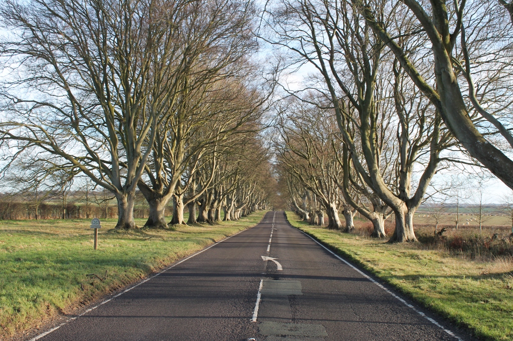
William John Bankes had them planted in 1835 to create a natural gothic arch of beauty. It is said that this was in honour of his mother Frances. The beeches are fabulous any time of year. The sunlight will flicker through October russets.. or perhaps the intense green of May. But now, with the leaves almost gone, the low sun will intensify their silhouettes and their smooth forms will create unique trunk and branch-scapes, a parade of bold pleasing patterns with glimpses of Badbury and the wider Estate farmland beyond..

On one side of the road, 365 trees … one for each day in a usual year. On the other side 366..an extra tree for leap years. All nicely aligned and regularly spaced but each using its 185 years of life to grow into its own unique natural form.

The storm of October 1987 hit the avenue badly, blew over many of William John’s trees and though most survived, many were shaken to their roots and became unstable. Many more were affected in 1990. The storms reminded the National Trust that the avenue would not live for ever. A long term plan was needed. And so it was decided that a second avenue would be planted on either side of the 1835 trees.

This image has an empty alt attribute; its file name is 199002-322-027.jpg
The fallen trees along the Beech Avenue after the storm of January 1990

In the Hillbutts Kingston Lacy Estate Office, I was shown the plans and compared the proposed tree plantings with ancient features visible on aerial photographs. The trees that had fallen in 1987 had torn up chunks of archaeology in their roots, and the planting of new trees would also destroy archaeological information. This would take place gradually as their developing roots infiltrated and disrupted the buried stratigraphic layers of information below the ground.

We plotted the known archaeological sites where they lay in the path of the proposed new planting and persuaded the Estate to allow us to dig where the trees would go.

At the west end of the avenue, there was a good opportunity to take two Bronze Age round barrows out of arable cultivation to preserve them under grass. Good conservation practice that would protect these burial mounds far into the future. It meant that there would be a short gap on the south side of the avenue, but the managers agreed to this because these mounds were scheduled monuments of national importance.

One of the barrows might be the famous Badbury Barrow where Rev Austen found many burials and a stone.. carved with daggers (see blog Badbury Barrow and Rock Art 26th August 2018).

This was our winter of 88-89, working along the beech avenue investigating the archaeological lines seen on aerial photos where the trees would go. Usually there were three of us, me, Nancy and Rob…and the Estate let us have an old white caravan to shelter in for tea breaks and store the tools.

We began at the west end with a 60m diameter ring ditch beside the Swan Way trackway. This was part of the group which included the two we had removed from arable.

This image has an empty alt attribute; its file name is 198902-311-008.jpg
The Bronze Age 60m diameter ring ditch beside the Swan Way at the wwest end of the Beech Avenue.

A JCB stripped the ploughsoil as we watched. It turned out that everything had been scoured down to the bedrock and there were furrows cut into the chalk as though a steam plough had been used to subsoil the interior of the site. However, the 1.25m deep ring ditch was still filled with Bronze Age archaeology. It measured 4.2m wide at the surface and narrowed to 1.7m wide at the bottom. Its flat bottomed ditch was once the quarry around a now lost burial mound. Debris from funerary deposits formed part of the filling, including a human hip bone and fragments of a c.3,000 year old Deveral Rimbury barrel urn…..At a deeper level were clusters of flint flakes that fitted together. We imagined someone in the Bronze Age, sheltered in the hollow of the silted ditch, making tools out of chunks of stone..

In January, our caravan was moved east to the grassland south of Badbury. Here, we started to look at a large ditch which had been part excavated in 1965. At that time, there was a bank beside it, they found a 1st century ballista bolt under its eroded edge…but after the dig, the whole thing was bulldozed flat. We found the caterpillar tracks of the earthmoving machinery etched onto the chalk bedrock…and old tin cans which once held evaporated milk… from the excavation tea breaks… tossed into the backfill.

This image has an empty alt attribute; its file name is 198903-313-010.jpg
The deep Bronze Age ditch near Badbury Rings which continues south to Shapwick a huge excavation. At the top below the plough soil and horizontal ranging pole you can see the jumbled soil above Nancy’s green safety helmet. The evidence of the 1965 excavation.

Below this, thousands of years of silting, with sherds of c. 3,700 year old Middle Bronze Age pottery found over 2m down in the lower silts. This was a huge construction, a sharp ‘V’ shape over 4m wide and 3.2m deep. The air photographs showed it crossing under the line of the Blandford Road, running south for 1.5km to the edge of Shapwick village and then turning abruptly west and continuing across the Estate. The bank had been on the east side of the ditch and an earthwork of this scale was surely a fortification against some unknown and forgotten Bronze Age threat in the direction of Blandford. We discussed it over tea in the caravan … alongside politics, philosophy and religion.. but came to no agreement.

The weather was kind to us and from time to time visitors came to help and asked how we were getting on.

Angus, the farmer, had noticed patterns after ploughing and took us out to show his discoveries. Here were the clear soil marks of ancient stock enclosures that had emerged that winter in his fields. We walked across the ploughsoil and picked up Roman pottery.

This image has an empty alt attribute; its file name is kingston-lacy-nt403-6-feb-1989.jpg
The soil marks of the Roman stock enclosure ditches photographed by model plane in February 1989

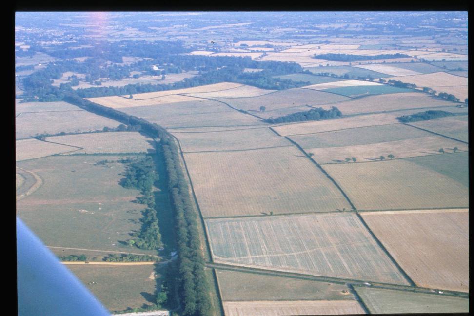
David, the Kingston Lacy warden showed us where he had found a Late Bronze Age palstave axe in a drainage trench beside our excavation. He introduced us to a man with a model plane with a camera fixed to it and we welcomed his offer of flying the Estate. His photos of the soil marks are some of the best we have.

We came across no other bronze metalwork but instead found a ring of posts-holes with Bronze Age pottery in the fillings. The remains of a timber framed round house complete with a porch. Its intercutting post-holes showed that it had been repaired more than once….as the timber uprights rotted and needed replacement.

This image has an empty alt attribute; its file name is 198903-313-016.jpg
One of the pairs of post-holes of the round house.

Seeing how they secured the house uprights with flint nodules rammed into the post-holes against the timber… we copied our ancient ancestors to create a stile over the fence for easy access to our caravan.

Further east… and the A-team turned up for the day. My Sunday School class, who were already veterans after two expeditions to the digs at Corfe Castle. They tackled a shallow scooped profile ditch which had the root holes from an ancient hedge beside it. The filling contained Romano-British pottery. We found three ditches like this as well as the side ditch of the Roman road to Dorchester.

One of the rounded shallow ditches (left) and small v shaped field boundary ditches (right)

Our last finds were two small ‘V’ shaped ditches which contained earlier pottery. We had found a similar ditch when we dug across Kingston Lacy’s amphitheatre the previous year (see blog ‘Kingston Lacy’s Roman Amphitheatre’ 15th February 2014). These ditches are part of the ‘celtic field system’ dating back to the Bronze Age and still visible as white ghost lines on aerial photographs after ploughing.

We had expected snow, wind and torrential rain but December to February that year had been good to us. We felt sad to load up the tools and say goodbye to the old white caravan.

This image has an empty alt attribute; its file name is img_5268.jpg
Another fallen tree in 2014 with the new avenue growing beside it.

Since then, I have driven along Kingston Lacy’s beech avenues many many times times and seen the new trees growing and the old trees becoming a little fewer year by year. I rarely need to stop.. but in March I went back to the gap for the barrows beside the Swan Way. It was a meeting with Bournemouth University to plan for geophysical survey and a new research project to locate the Badbury Barrow.

This image has an empty alt attribute; its file name is img_5244.jpg
The short gap in the new avenue on the south side of the old avenue where the two scheduled Bronze Age burial mounds were taken out of arable and included in a new hedged area of permanent pasture beside the Swan Way track (on the left edge of this photograph)

It was strange to be back. I placed my hand on the trunk of one of the trees.. now over 30 years old. They’re growing well…back then they were saplings, with stems less than a wrist thick… but now they are grown over 30cm across. They are well established now… all set for the 22nd century.

This image has an empty alt attribute; its file name is img_5270.jpg
The west end of the Avenue forming a living gateway to the Kingston Lacy Estate with the new avenue growing either side of the surviving 1835 trees.

Trees are planted for the future… and… as I consoled myself…even William John, never expected to see his great avenue achieve its full glory.

Long Bredy, The Cleaning of Bones

This week: the LiDAR survey report for the Stourhead Estate was completed; at Chedworth we understood the drains; a meeting at Brean Down gave context to a 65,000 year old horse’s tooth, and, on the northernmost edge of the South West Region… geophysics has begun to provide evidence for the origins of Hidcote.

Wonderful stuff.. and all for future consideration, but my heart is still at Long Bredy and our recent excavations there.

I walk on past the parish church, and up, steeply, through the pasture field to the Ridgeway’s western edge. The sheep watch the figure follow the spine of Martins Down bank barrow. Stopping to enjoy the wide fading landscape, out across Golden Cap to Start Point. Then back through a field of ripening wheat and down a deep grassy hollow-way, back past the church to my tent. Everything glowing red in the setting sun, every strand of grass richly pink and the wool strands hanging sharply in the wire.

Looking towards Long Bredy church from the hollow-way

One day, when it seemed that we would run out of time. A long day of mattocking, barrowing.. collecting fragments of flint and small sherds of red-black pot. Level after level of 5cm spits of soil. I came back to continue on into the evening and Rob said he would too …but the energy was gone… we exchanged glances and eventually stopped, limply putting the tools away.

The cluster of large stones overlying the burials cut by the 2013 pipeline

The next morning, the lumpy surface turned into a cluster of large stones and we began to carefully lift them one by one. Each stone covered human remains, broken and impacted by their weight over the millennia. Three crushed skulls and a jumble of long bones.Yellow and fragile mixed with soil and roots. The roots looking like bones and intermingled with them. A trowel, a plastic spatula, a pair of secateurs and a fine brush.

A view of the three skeletons looking north

Then the cleaning of bones. A long quiet day, crouched in a trench in a field. Nothing else, just the gentle loosening of soil around them. The initial shock and concern.. then yielding to beauty. The realisation of practical creative design, every curve and facet. A broken pair of shins is exposed; delicate, hard and finely formed. You stroke your own, feel the tibia below the warm skin. Then the softer bones of the feet, a jumble of tarsals. Extraordinary heel bones and the wonder of toes.

The northern teenager with feet and legs bent above the head.

We brought back the bones, gathered from the 2013 pipe trench. We took away a few small fragments for DNA and strontium isotope analysis. Once we had cleaned them, Clare came and analysed the skeletons. Two teenagers, one with head to north and one with head to south. One tightly bound and face down, one doubled with feet above the head and the third, a young adult, crouched, the last to be buried. Most of this one gone after the JCB struck six years ago.

A dry fortnight ..but as we packed up it started to rain.. though by that time Nancy had protected the skeletons. Carefully covered, then placed them under a blanket of sieved soil. The stones were put back in place and then Clive brought the digger and pushed the spoil back over the trench. The flint and chert flakes and tools, the pottery and the animal fragments together with the samples from these three 2700-2800 year old people will all tell more of the story.

We will wait, and in the mean time…

I will appreciate the intricacies of my feet.


Burnt Mound, the story so far

The garden seat at Shedbush Farm, Golden Cap Estate. Time to analyse the evidence and tell the story of the site.

The garden seat at Shedbush Farm, Golden Cap Estate. Time to analyse the evidence and begin to tell the story of the site.

The soil is back in the trench and we are left with the drawings, the photographs, the soil samples and the finds.

What does it all mean?

We started with a leaflet on burnt mounds produced by Historic England. It concluded that..nobody really knows what they were constructed for but most are found beside water courses and have a trough beside them. This has led to the idea that stones were first heated on fires and then thrown into the water filled trough. The hot water might then be used to create a sauna or sweat lodge or could be used to steam heat food for feasting perhaps. The hot rocks on cool water caused them to shatter and the waste fragments were regularly cleared from the trough and heaped into a mound beside it.

Nice ideas but our location was not beside water. We found that pushing a small container full of water up hill in a wheelbarrow was hard work. The stream flowed in the valley, beside the car park, about 20m down slope from us. There may have been a trough but we did not find it, unless it had dropped off the cliff or lay outside our deep narrow trench.

Our mound is made of lots of small blackened pieces of Upper Greensand sandstone and chert mixed with ashy silt and towards the bottom increasing amounts of clay. The product of a lot of work.. collecting and burning the wood and stones to break them down into such as small size. A very windy spot, on a shelf of land half way up Ridge Hill.. now Ridge Cliff because since the Bronze Age the sea has claimed most of it.

The mound is the waste product of a process. It looks like an industrial waste heap..if so, what was produced here? Perhaps stone was broken up to create temper to hold pottery together during firing. No pottery found in the mound though. Perhaps metal was worked nearby.. no slag in the heap though. Just stone and charcoal and clay.

These were farmers and good agriculture was a matter of life and death so could the mound be anything to do with soil productivity. A few generations ago, charcoal and stone were the ingredients to feed the kilns which were used locally to produce lime that was spread on the Victorian arable fields to counteract the soil’s acidic nature.Producing lime from local stone requires high temperatures and careful stacking of ingredients. Without a stone kiln structure perhaps the windy hillside would enable a fanning effect to increase temperature within a Bronze Age stack. This explanation is not very satisfactory…

Perhaps the mound is a pyre. A significant feature never understandable to us because we cannot comprehend the belief system that created it. Too easy and a bit of a cop out but perhaps true.

Above the mound we found flint scrapers and a few bits of chunky coarse grained Bronze Age pottery but the C14 analysis of the charcoal will confirm or deny our current estimate of about 1000 BC.

Nancy working on one of the Iron Age ovens high above the top of the Bronze Age burnt mound. About 40 generations had come and gone since the final cooling of the burnt mound and the lighting of the oven.

Nancy working on one of the Iron Age ovens high above the top of the Bronze Age burnt mound. About 40 generations had come and gone since the final cooling of the burnt mound and the lighting of the oven.

At the west end, the mound was cut by a later ditch and above this we found the two ovens. Not kilns we think now. Their entrances are simple and facing the prevailing wind to the south-west. The pottery in and around them seems to be Late Iron Age, about 2000 years old but apart from the ovens and the cluster of pottery around them, no post-holes or other settlement features were found at this level. There were a scatter of stone finds which suggest local industry here. The kind of roughly worked flint which is found in Purbeck interpreted as lathe bits to turn shale bracelets. We only found one chunk of shale at Seatown though. This was far from its geological source in Kimmeridge.

I came across a cube of green flint. It looked like an exotic mosaic cube when it was first brought up by the mattock. Other fragments were found at the same ovens level and they were obviously selected and brought here for a reason. Ali, the site’s geologist is looking into the source of this rock. Perhaps used and worked to create jewellery?

So we need to go away and analyse the samples, look at the soils and the ancient pollens within them examine and compare the finds.

It was good to hear Mike talk about the soils when he visited and I could see them change as I drew them. rising up the section beyond the last flint finds. Ploughing each season, helped by gravity dragged the soils down from above. This land was part of Chideock’s open fields in medieval times before the land was enclosed in 1558. About 20cm below the surface we found 17th and 18th century pottery mixed with bits of slate… but by this time the soil was wind-blown sand.. a sign that the cliff was approaching fast and after 3000 years, the end of the burnt mound was nigh..

Evening over Golden Cap beginning the walk back to Seatown from the burnt mound.

Evening over Golden Cap beginning the walk back to Seatown from the burnt mound.

Day twelve – end of the section line


 Clive and his digger arrive on site

Clive and his digger arrive on site

The final day, nose to the grind stone, no tea break and a late lunch.

Martin cracked on with the last of the drawing and recording, Carol and Millie finished digging the eastern end. I attacked the possible second kiln/oven and finished revealing the opening of the first one. Rob and Fay went for the natural bedrock in their trenches, with help from Clive and his digger 🙂

Looking west along the trench Carol working in the eastern end and Martin recording the section


Martin recording the extra information uncovered in the eastern end of the trench

Martin recording the extra information uncovered in the eastern end of the trench


Due to the efforts of all the diggers Clive only needed to do one scoop to hit the bottom of the burnt mound material, the thin buried soil it was sat on and he top of the natural bedrock. The layer under the mound was very pale grey and silty. We took a sample of this to look for pollen and to look at the soil make up, one of many samples taken through the mound.

The small scoop taken out by the digger after Fay had cleaned it up, so we could see the layers better

The small scoop taken out by the digger after Fay had cleaned it up, so we could see the layers better

IMG_0861

The kiln/oven finally gave up its form, the charcoal spread out of the opening. The second kiln/oven had a layer of burnt clay but no charcoal under that layer, just a brown soil, but one side of the opening was very clear to see. Both had an opening facing the same way, west-south-west.

The kilns/ovens side by side

The kilns/ovens side by side

The charcoal was very well preserved as I found earlier. It’s amazing that the structure of the wood is locked by burning and we will be able to see what species it was thousands of years later.

Well preserved charcoal

Well preserved charcoal

Then the sad moment came for Clive to start filling in the trench, and time for us to eat a sandwich, re-hydrate and have some Women’s Institute lemon drizzle cake provided by Fay. Yummy!

Clive starts the back filling

Clive starts the back filling

We had one last task to do, with Clive happy to help we just dug out the area next to the kiln/oven to see if we had another one to the inland side, alas we didn’t but it was worth a look as we would always have wondered.

The last few scrapes

The last few scrapes

With one last look at the cliff edge that had been our ‘office’ for two weeks we headed down to pack up the tools and then for a well earned cuppa.

Martin and Rob reflecting on the last two weeks

Martin and Rob reflecting on the last two weeks

We will post updates about all the samples we took and the radiocarbon dates as we get them back from the specialists. The pottery and flints need washing before we send them for identification and dating. So keep watching the blog.

NEWS – The next dig will be Chedworth Roman Villa, from 18th August, see you there 🙂

Day ten – into the black


Alex and Fay in a hole!

Alex and Fay in a hole!

Time to tackle the mound material and the oven/kiln/hearth. With three days left we need to get as much information from the site as we can.

Ali, Alice and Carol carried on revealing a packed stone layer next to the mound layers in the east end of the site, Fay and Alex started to mattock out the mound layer to the west of the hearth/oven/kiln. Martin and Simon moved further west to find the edge of the mound. I was given the job of digging the kiln/oven/hearth.

Alex taking a level before bagging up a sample of  the mound material

Alex taking a level before bagging up a sample of the mound material

The black mound material

The black mound material

The black mound layer is quite thick and full of burnt flint, stone, ash and charcoal. As Fay dug into it she said she could smell the burning, a bit like when you clean out an old coal fire. It’s amazing, you can smell the past, for about four thousand years it has been locked up in the ground until Fay released it with one stroke of the mattock.

Fay digging out the mound

Fay digging out the mound

The girls working in the east end had a hard job defining the stony layer and were working very hard to get to the same black mound layer the others had. A healthy competition seems to have developed! 🙂 It’s funny how you become attached to an area and don’t want to move to another part of the site. Even if you are not finding anything it’s always a bad idea to change places with someone who is finding things. It’s like changing queues in a supermarket, it never works!

Carol, Alice and Ali working in the east end of the site

Carol, Alice and Ali working in the east end of the site

T`he stony layer on the left and the mound layer on the rigtht

T`he stony layer on the left and the mound layer on the right

I half-sectioned the kiln/oven so we can record the different layers within it. This section will be drawn and then the other side will be excavated. One sherd of pottery came from within the kiln/oven and three more pieces from where the flue may be.

The kiln/oven after the first layer is clean down

The kiln/oven after the first layer is cleaned down


The clay layer removed and the pottery sherd is near the bright orange area


A piece of charcoal, you can see the burnt twig

A piece of charcoal. You can see the burnt twig


The shallow section of layers in the kiln/oven

The shallow section of layers in the kiln/oven

The clay base of the kiln/oven

The clay base of the kiln/oven

Everyone has been working very hard. Alex and Alice are sixth-formers who couldn’t keep away from the trench, their breaks got shorter and shorter!

Alex and Alice doing a brilliant job digging the mound

Alex and Alice doing a brilliant job digging the mound

Day nine – Busy, busy, busy

Martin on TV

Martin on TV

Today was a great day for many reasons. We had visits from the media, 13 students from the local school at Beaminster, and environmental archaeologist Mike Allen (Allen Environmental Archaeology) on site. The students took turns excavating, sieving the material from the mound and searching the soil heap for missed finds the digger machine had dug up.

Students  excavating on site

Students excavating on site

Sieving the mound soil

Students sieving the mound soil

Students Searching the spoil heap

Students searching the spoil heap

Mike came to site to take environmental samples and to look at the soils on site, to help tell the story of the processes of burial of our features – the burnt mound and kiln/hearth.

Mike preparing his samples

Mike preparing his samples

He took soil columns to provide uncontaminated samples. He will take smaller samples from them to look for pollen. Also Mike will look at the structure of the soils to see how they were formed, for example by down-wash of soil from cultivated land further up the hill. We will up date what Mike finds in a future post over the next few months 🙂

In the foreground one of the columns of soil wrapped in cling film

In the foreground one of the columns of soil wrapped in cling film

Martin and Rob carried on removing the orange yellow soils on the west side of the kiln/hearth, and at about 11 o clock the whoop went up as they found the burnt mound layer. Hurrah! More worked flints had been found just above the mound layer, more blades and scrapers, and pottery.

Prehistoric pottery - very crumbly!

Prehistoric pottery – very crumbly!

A lovely flint scraper, it could have been used for taking hair of hides or meat from bons

A lovely flint scraper, perhaps used for taking hair off hides or meat from bones

Day Five – WOW!

The flutter of anticipation has been released into the blue sky 🙂 we have had a brilliant day, the site is blooming, struck flint and pottery coming out thick and fast! But the real star is the round yellow feature filled with deep orange with hints of black, more on this later 🙂 The picture below shows it just appearing as Martin mattocks gently the hard surface.

The feature can be seen as a red and dark brown black area next to the side of the trench

The feature can be seen as a red and dark brown black area next to the side of the trench

The pottery that is being dug up at the moment looks more like Iron Age pottery than Bronze Age. It seems a bit different to the pottery we are used to finding in Dorset and may have more in common with pottery from Devon and Cornwall. At the site we excavated just over the hill, at Dog House, we found Bronze Age pottery from near Bodmin, in Cornwall. One piece that came from the feature described earlier, was an exciting surprise, showing a deep incised decoration of hatched lines (see picture below)

The small piece of decorated pottery. We hope we will find more

The small piece of decorated pottery, hopefully we will find more

Now back to the feature, it was very dry and did not look very impressive, so it was down to the garden center to get a water spray and Tommy went off to the rangers office to get some water. It was well worth the journey through the holiday traffic, as the spray soon highlighted what could be a hearth or kiln of some kind!  It was definitely a Wow moment 🙂 The yellow is the sides or wall with orange clay in the middle and a charcoal layer just appearing lower down.

The outer yellow of the 'wall' of the hearth/kiln/fire pit

The outer yellow of the ‘wall’ of the hearth/kiln/fire pit

The feature is right in the middle of the trench

The feature is right in the middle of the trench

We said goodbye today to Ray, our barrower supreme. Thanks for staying to help, you were a valuable member of the team, especially as I am out of action due to a  dodgy shoulder.

Ray 'Mr Barrow' Lewis take a bow :-)

Ray ‘Mr Barrow’ Lewis take a bow 🙂


Day Four – and there’s more


The site looking East

The site looking East

The trench is holding on to its secrets, we are still going down, but it’s slow, exhausting work, as the ground is so hard and the weather so hot. But progress has been made by the diggers, and there has been more pottery and some lovely quality flint tools found today. The flutter of anticipation is still there and with every mattock swing we may just uncover the ashy charcoal layer filled with answers to the many questions we have about the site.

The mattock gang

The mattock gang

Today we were joined by Robin who was on his holidays but very interested in what we were doing. He came to help find any objects the diggers had missed. He set to work on the spoil heap and found a piece of prehistoric pottery and some struck flints. Sadly soon his Dad came to get him as the car was packed and they had to wend their way back home to Scotland. Hope to see you again Robin when you are older and we can come and help on a dig you are running 🙂

Robin and his Mum finding archaeological finds on the spoil heap

Robin and his Mum finding archaeological finds on the spoil heap

A very happy Robin

A very happy Robin


Possible Bronze Age pottery found today

Possible Bronze Age pottery found today


Day two – someone turn the fan off!

A clear day and a good view of Golden Cap

A clear day and a good view of Golden Cap

Still windy on the hill, so the goggles were handed out, as we had the site to tidy up and to remove  the loose soil left in the trench  by the mechanical digger. Sections (the sides of the trench) were cut back and straightened, and the layers numbered. We were joined to-day by Alex and Tasha two sixth formers from Warminster and Antony who originally found the site.

Tasha, Alex, Carol and Antony working on straightening the section

Tasha, Alex, Carol and Antony working on straightening the section

More objects have been found including some 18th century pottery, that maybe came  from a jug of drink brought out to workers in the fields,  deeper down we came across some prehistoric pottery and some classic struck flint.

Prehistoric pottery

Prehistoric pottery

Struck flint

Struck flint

Alex cleaning the section

Alex cleaning the section


If you go down to the cliffs again…


Golden Cap in the distance and the cliff at Seatown in the foreground

Golden Cap in the distance and the cliff at Seatown in the foreground

Three more sleeps until we are back excavating next to the cliff edge in West Dorset. A mysterious mound of burnt material was spotted eroding from the cliff face by local archaeologist Antony who drew our attention to it. It is buried about 1m down and therefore was not visible on the surface.

This kind of feature is called a ‘burnt mound’ and are more commonly found in the Midland of England and in Scotland. There are sites in Hampshire, Wiltshire and North Dorset, but this is the first found in West Dorset. Burnt mounds can date from the Neolithic right up to the Iron age, with many Bronze age in date.

We don’t know if this burnt mound was something used for ritual feasting, a sweat lodge or an industrial site but hopefully over the next two weeks we will may be able to shed more light on its purpose and age. So watch this space 🙂

The layer of burnt flint and stone can be seen in the middle of the picture

The layer of burnt flint and stone can be seen in the middle of the picture