Woodland at Bishops Court, Kingston Lacy

I’m not kind to cars.

There was the Vauxhall Nova incident at Golden Cap, the Escort at Thorncombe Beacon and today my Seat Ibiza is bumping across the old stubble of Bishops Court Farm, windscreen-high in vegetation, the wheels bumping along over hidden hazards.

I need to take the tools to the trench-side and Clive and his JCB are cutting into the old ploughsoil, their linear trench now hundreds of metres long.

Two distant people at either end of a white chalky gash in a huge field. Today, just Clive and me with the birdsong, surrounded by the wilding bushy hedges … now off-green and golden.

A herd of deer cross the horizon.

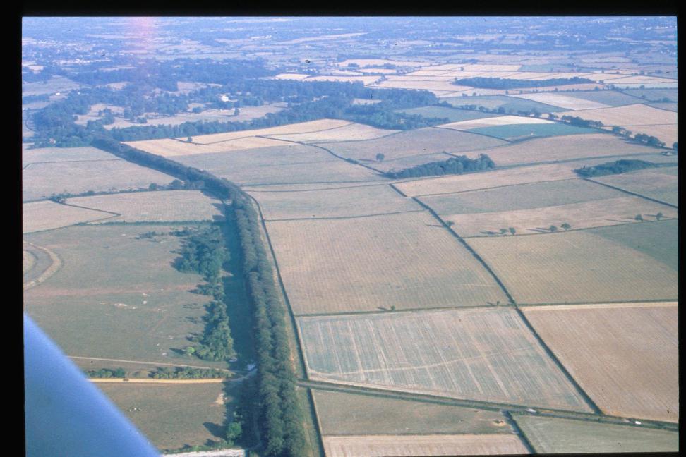
A transformation of four years ago when this 300 hectare arable farm was taken out of the plough. The grain fields productive yet mono-habitat prairies, the hedges close clipped.

The last tenant decided to retire and handed this farm back to the National Trust. Then Covid came and the farmland rested and began to ecologically diversify. All sorts of birds, animals and plants are returning.

Controversial though…. how does nature link arms with commercial farming. This has been a farmed landscape for at least five and a half thousand years. Treading the path to enable productive farming with rich habitats is the golden thread.

There are now plans to create new woodlands with other areas that will become scrub pasture…survey here in the future will not be possible.

Though this land has been ploughed for many generations, archaeology will still survive where features cut into the chalk bedrock. In the right conditions, aerial photography will reveal these hidden features…. and Bishops’ Court certainly has archaeology.

Back in 2014, Wessex Water cut a pipeline across this land and the archaeological recording work revealed all sorts of prehistoric features…including a Bronze Age palisade of close-set tree-sized post-holes backed by a boundary ditch.. elsewhere, by the Dairy, a cemetery of barrow sites.

https://archaeologynationaltrustsw.wordpress.com/2014/04/06/kingston-lacy-the-drone-the-pipeline/

Over the decades, the roots of the trees to be planted in 2023 will seek out nutrient rich archaeological deposits as they grow. What the ploughing avoided, the roots will disrupt.

That’s the theory so…

Find the archaeology and avoid planting there. Make the woodlands where the archaeology isn’t.

At Bishops Court, the National Trust are funding largescale geophysical survey to map the buried remains… and this year, 150 hectares of land have been traversed by Tigergeo Ltd. They have driven their magnetometer buggies across the fields capturing the archaeology.

The prehistoric environment can now be seen and understood on a landscape scale.

This place, was a medieval manor west of Shapwick village…merged with Kingston Lacy.

I walked the farm with Steve and Rebecca the nature and farming advisors.

Its perimeter is higher ground sloping into a gentle dry valley leading south to the meadows beside the River Stour.

A world in itself… the farm now establishing a new identity.

The geophysics shows a complicated network of connected linears on the western upland with settlement enclosures attached. Nearby, are the attendant scattered ring ditches of earlier Bronze Age burial mounds. To the east, along a localised ridge is a row of round barrow sites. Other settlements, boundaries, trackways and field systems cross the area.

It was good to do the survey before the vegetation became too established. Even now, the development of nature makes it a difficult decision to top the ground to enable the next phase of geophysics.

My sense is to grab the survey opportunity before its gone.

The data is so good …it has the appearance of looking into the night sky. So many stars… but what lies beyond them ? Are there significant sites that glimmer only faintly from the geophysical survey plot… or, perhaps they are hidden.. perhaps they do not respond to magnetometry at all? Are we missing anything?

The answer was to put a long trench across a surveyed area which seemed almost blank of features. One of the candidates for woodland planting.

Luke, Harry, Dave and Nancy watched the digger to see…. and the answer was reassuring. The regular deep ploughing of this land had scraped the soil down to chalk, the modern cultivation disturbance 30-40cm deep.

Our 250m long trench found only the long boundary features seen on the geophysics.

At 15m a small ‘U’ shaped ditch with an oyster shell, at 22m a deeper field ditch, a recut of a shallower earlier boundary with an Iron Age sherd in the backfill. At 70m a shallow boundary scooped into the chalk with a later Bronze Age piece of pot.

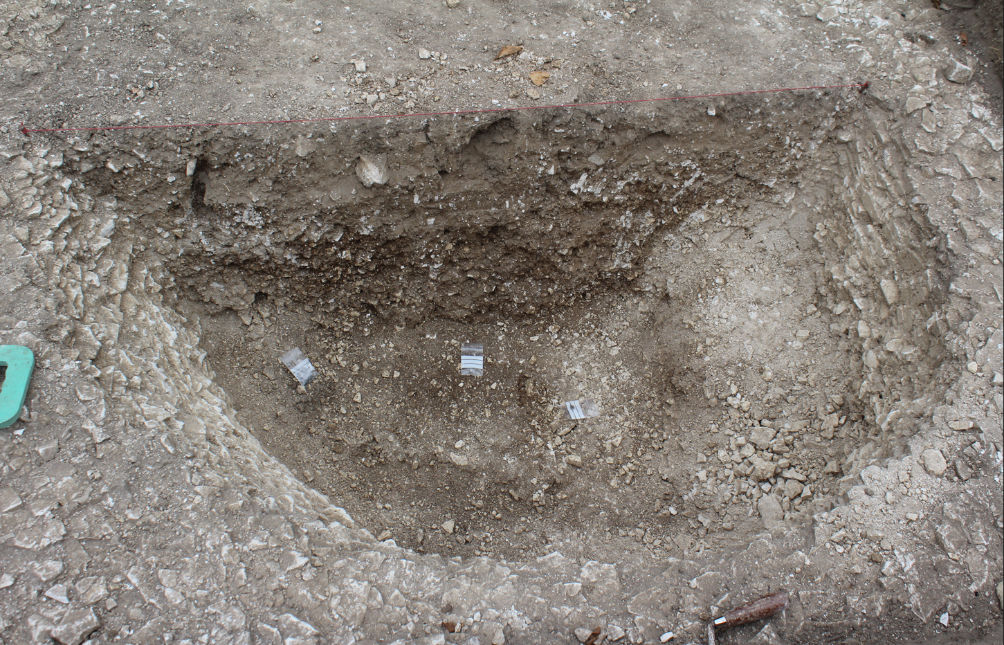
And beyond this.. at 80m? .. I’d come back to finish things off… early morning, for a couple of hours …to complete the excavation of a pit … nothing was found beyond it….. just hundreds of metres of plough-scored white chalk.

The pit was irregular, mixed with chalk and flint.

Mattocking…with that sense of solitude.. with the hum of the digger in the distance… backfilling the trench.

The wide overcast sky, the threat of the storm to come, my silver thermos, the drawing board, the tape measures ….and the abused Seat Ibiza backed up to the trench.

No finds at all. The feature probably the root bowl from an ancient windblown tree.

Well.. the trees would return here. Our geophysics safeguard was good and the evaluation trench backup was reassuring.

I said a fond farewell to Clive. I guess we won’t meet again.

The Cerne Giant: Stuart Piggott 1945

The National Trust is now 128 years old and in its archives lie many hidden historical delights.

I bumped into one last week while researching the book which will publish the National Trust’s archaeological excavation, carried out in 2020, which dated the Cerne Abbas Giant.

The Cerne Giant c.1935 Ashmolean Museum, Oxford

The early correspondence lies deep in the Wansdyke tunnels somewhere in Wiltshire. To call it back, the ARMS digital database needs to be consulted… Nicky looked up the file references for Cerne Abbas and ordered the boxes.

A few days later they were delivered to our Tisbury Office.

The files contained a great collection of photographs, collected for the management plan of 1974. One dated back to 1890… but it was the correspondence concerning the Giant which was particularly fascinating. The letters take the reader back to another world.

One group of letters was dated September 1925 , between the writer Thomas Hardy at Max Gate Dorchester and Sir Henry Hoare at Stourhead… the Giant was always green ‘and never all over white like King George’s near Weymouth’

But the file that caught my eye contained letters from 1945 to 1948 and concerned conservation work and research overseen by Stuart Piggott.

If you have seen the film ‘The Dig’, Stuart Piggott (played by the actor Ben Chaplin) with his wife Margaret (played by Lily James) were part of the team of archaeologists invited by the British Museum to dig the great Saxon ship burial at Sutton Hoo in 1939…. on the eve of WWII.

Stuart had had already written an article in 1938 comparing the Cerne Giant to Hercules and he was of the opinion that he dated to the Roman period.

During WWII, Piggott was posted to India and was involved in surveillance and interpretation of aerial photography.

Our first letter is from the Clerk of the Cerne Abbas Parish Council L.H. Shutter and is dated 13th June 1945.

This is barely five weeks after the Victory in Europe celebration on May 8th.

It requests action from the National Trust concerning the neglected condition of the Giant.

‘It is now much overgrown and not very distinguishable…it is such a centre of attention by visitors and Parishioners’

The letter was sent to Edward Eardley Knollys who in his reply to Mr Shutter described himself as the Area Agent for the National Trust’s properties in Dorset (though he was an established artist and curator before being recruited to the NT by James Lees Milne). Knollys promised to contact the Trust’s Archaeological Advisor Sir Cyril Fox.

Sir Cyril immediately recommended Stuart Piggott to carry out the work and Knolly’s letter to Piggott’s family home in Rockbourne, Hants is met with a positive response …..but there is a problem.

The shortages of post-war Britain. Knollys writes to Fox suggesting a personal request to Raby at the Ministry of Works ‘would do the trick’ to obtain the much needed petrol coupons.

His letter of 30th July to F.J.E. Raby Esq.at the Ministry requests scheduled monument consent to repair the Giant and 12 petrol coupons.

The letter of consent is sent on 1st August by a Mr Miller. The Ministry is still at its war time location of the Palace Hotel Rhyll, Flintshire. Miller mentions in a P.S….. how he might obtain the National Trust’s new ‘Jubilee’ publication. A reminder that 1945 marked the Trust’s Golden Jublilee ….50 years after the conservation charity’s foundation in 1895.

3rd August: Sir Cyril Fox had pulled the right stings…. Eardley Knollys writes to Piggott ‘Here are your petrol coupons. All is agreed. Go ahead with Hercules’

Stuart Piggott’s first letter on site is dated 16th August. His mission is to erect a fence around the Giant to stop cattle and horses eroding it and to clean the trenches out and repair turf so that the figure would be visible again.

Lord Digby owned the land around the Giant, the Trust only owns the Giant itself. ‘Victory’ in the letter is a reference to Victory in Japan day 15th August.

the second part of this letter reveals an additional element of Piggott’s work on the Giant. He planned to test by excavation whether the Giant’s outstretched arm once had the representation of a ‘Lion’s Skin’ draped over it.

As I wrote at the start .. Stuart Piggott was sure that he was both Roman and an image of Hercules.

I’ll pause here for now…

Return to Max Gate

The front door is open and from where I kneel in the trench, cleaning chalk, I can hear the sound of the piano tune…a Victorian Romance.

The view across the reopened trench looking across to the front door of Max Gate

Sue talks to her group. She tells of Thomas the architect, his trip to Cornwall and how he met Emma and they fell in love (‘A Pair of Blue Eyes’).

Max Gate their home in later life after Hardy had established himself as a writer.

A voice from above.

‘You’re back then’

I stand to reply.

‘In the end I had to. We found no dating evidence in July. I thought that… before the trenches are hidden… by new grass or the new front drive.. there was still a window of opportunity to take some samples.’

I say the three tongue twister words again… optically stimulated luminescence…dating from quartzite crystals.

Taking the OSL sample from the ditch section the tube is right of the red marker.

I find the best point in the prehistoric? ditch section …and hammer a black plastic pipe into it.

Not easy… as several times it judders to a halt ..on hidden flint nodules.

In the end I got two 20cm long samples, wrapped them in labelled parcel tape and marked the locations on my section drawing. Then I walk back through the garden and into the paddock to find Pete in the pit.

Sarah had dug some of this in July …but like the front door ditch, the excavated filling contained nothing really to date it… just a few flint flakes and one fragment of pottery. Nothing organic though to get a C14 date.

On the first morning, we’d measured along the trench edge, marked out a 3m square and re-exposed the pit. This time, extending the old trench line by a metre to get the full outline of the pit cutting.

The pit after re-excavation to point we left it in July apart from our metre extension (top of photo)

In July, I’d thought the pit was circular and I had a feeling it might be an Iron Age grain storage pit…nice but about 2500 years too recent. In our extension we discovered that it was oval in plan…not so Iron Age after all.

Now, on our second day and almost 1m down Pete has found a larger chunk of pottery and two patches of charcoal. The sherd.. could be Neolithic… and the charcoal would give a date but there were 3 hours left to get as deep as possible.

The pit section 1m deep with the collapsed weathered chalk at the edges. The darker middle fill contained a fragment of prehistoric pottery and two small patches of charcoal contained in the plastic finds bags.

The filling was now collapsed chalk from the weathered sides of the pit with less chance of artefacts being found amongst it.

We talked again about the 1980s excavations which uncovered the west half of the circular Middle Neolithic enclosure… now swept away by road construction.

Back then, some of the pit and ditch sections had smooth chalk walls and these had been inscribed with exceptionally rare… maze-like art or graffiti.

I left that thought in the air as I walked back to the garden.

The home the great writer Thomas Hardy designed for himself..Max Gate. The circular parch mark in front of the bench and megalith found during the 1980s excavation and donated to Max Gate. Linear parch mark to right leading to parched area in foreground.

The dry weather had created parch marks which I plotted on the site plan. One 3m diameter circular parch mark was found in the front lawn near a diagonal linear feature and opposite the megalith left at Max Gate from the 1980s excavation.

Back again to the paddock and there was time to sieve the soil from the pit.

This revealed a few more struck flint flakes, a couple of snail shells and another small black piece of thin pottery. The ceramic specialist will analyse the fabric of our three sherds from the pit and pass judgement on their age.

Pete was now 1.4m down and we’d run out of time. He’d found two smooth faces of chalk stepped one above the other and a section of darker soil at the deepest level.

“Anything on the chalk? What do you see?”

“There are marks… but generally it looks quite smooth”

We changed places. I jumped down. Pete passed down a finds bag and I troweled a soil sample into it. There was definitely charcoal and ash in the darker material. Hopefully enough for a radiocarbon date.

Then I looked at the vertical face of the pit wall.

In all directions… angled down and sideways, the rounded pointed ends of marked indentations. In that intimate, deep place.. hidden for 5,000 years…now uncovered for an hour…

On the smooth chalk face of the pit numerous pointed indentations the impact blows of the antler pick. Traces of a darker chalky soil with ash beneath the chalk rubble filling.

I imagined our fellow digger.. armed not with a 4 inch cast steel pointing trowel but swinging his red deer antler pick again and again against the chalk and leaving this evidence behind….

and just above the chalk rubble, still filling the pit, there were traces (perhaps) of vertical inscribed lines… but further excavation was needed…

The pit at the limit of its excavation. The ranging rod divisions 0.2m.

Just the two of us saw it. We’d run out of time. We drew the section and took the photographs and buried it… but … yes….we now had what we needed.

Kingston Lacy: Digging the Beech Avenue

This story goes back to the early days, when Nancy and I were archaeologists employed by the National Trust’s Kingston Lacy and Corfe Castle Estates. Mr Bankes had given his land to the NT just 6 years earlier. It was the winter of 1988-89.

This image has an empty alt attribute; its file name is kingston-lacy-43509-aug.-1995.jpg
Kingston Lacy’s Beech Avenue heading east towards Kingston Lacy Park. The edge of Badbury Rings on the left

When driving towards Wimborne Minster from Blandford Forum, the boundary of the Kingston Lacy Estate is clear. After the village of Tarrant Keyneston, the road rises from the valley. At the crest of the slope, suddenly, the great beech tree avenue begins. Hundreds of mature graceful trees flank the road all the way to Kingston Lacy Park, a distance of 3km.

This image has an empty alt attribute; its file name is img_5270.jpg

William John Bankes had them planted in 1835 to create a natural gothic arch of beauty. It is said that this was in honour of his mother Frances. The beeches are fabulous any time of year. The sunlight will flicker through October russets.. or perhaps the intense green of May. But now, with the leaves almost gone, the low sun will intensify their silhouettes and their smooth forms will create unique trunk and branch-scapes, a parade of bold pleasing patterns with glimpses of Badbury and the wider Estate farmland beyond..

On one side of the road, 365 trees … one for each day in a usual year. On the other side 366..an extra tree for leap years. All nicely aligned and regularly spaced but each using its 185 years of life to grow into its own unique natural form.

The storm of October 1987 hit the avenue badly, blew over many of William John’s trees and though most survived, many were shaken to their roots and became unstable. Many more were affected in 1990. The storms reminded the National Trust that the avenue would not live for ever. A long term plan was needed. And so it was decided that a second avenue would be planted on either side of the 1835 trees.

This image has an empty alt attribute; its file name is 199002-322-027.jpg
The fallen trees along the Beech Avenue after the storm of January 1990

In the Hillbutts Kingston Lacy Estate Office, I was shown the plans and compared the proposed tree plantings with ancient features visible on aerial photographs. The trees that had fallen in 1987 had torn up chunks of archaeology in their roots, and the planting of new trees would also destroy archaeological information. This would take place gradually as their developing roots infiltrated and disrupted the buried stratigraphic layers of information below the ground.

We plotted the known archaeological sites where they lay in the path of the proposed new planting and persuaded the Estate to allow us to dig where the trees would go.

At the west end of the avenue, there was a good opportunity to take two Bronze Age round barrows out of arable cultivation to preserve them under grass. Good conservation practice that would protect these burial mounds far into the future. It meant that there would be a short gap on the south side of the avenue, but the managers agreed to this because these mounds were scheduled monuments of national importance.

One of the barrows might be the famous Badbury Barrow where Rev Austen found many burials and a stone.. carved with daggers (see blog Badbury Barrow and Rock Art 26th August 2018).

This was our winter of 88-89, working along the beech avenue investigating the archaeological lines seen on aerial photos where the trees would go. Usually there were three of us, me, Nancy and Rob…and the Estate let us have an old white caravan to shelter in for tea breaks and store the tools.

We began at the west end with a 60m diameter ring ditch beside the Swan Way trackway. This was part of the group which included the two we had removed from arable.

This image has an empty alt attribute; its file name is 198902-311-008.jpg
The Bronze Age 60m diameter ring ditch beside the Swan Way at the wwest end of the Beech Avenue.

A JCB stripped the ploughsoil as we watched. It turned out that everything had been scoured down to the bedrock and there were furrows cut into the chalk as though a steam plough had been used to subsoil the interior of the site. However, the 1.25m deep ring ditch was still filled with Bronze Age archaeology. It measured 4.2m wide at the surface and narrowed to 1.7m wide at the bottom. Its flat bottomed ditch was once the quarry around a now lost burial mound. Debris from funerary deposits formed part of the filling, including a human hip bone and fragments of a c.3,000 year old Deveral Rimbury barrel urn…..At a deeper level were clusters of flint flakes that fitted together. We imagined someone in the Bronze Age, sheltered in the hollow of the silted ditch, making tools out of chunks of stone..

In January, our caravan was moved east to the grassland south of Badbury. Here, we started to look at a large ditch which had been part excavated in 1965. At that time, there was a bank beside it, they found a 1st century ballista bolt under its eroded edge…but after the dig, the whole thing was bulldozed flat. We found the caterpillar tracks of the earthmoving machinery etched onto the chalk bedrock…and old tin cans which once held evaporated milk… from the excavation tea breaks… tossed into the backfill.

This image has an empty alt attribute; its file name is 198903-313-010.jpg
The deep Bronze Age ditch near Badbury Rings which continues south to Shapwick a huge excavation. At the top below the plough soil and horizontal ranging pole you can see the jumbled soil above Nancy’s green safety helmet. The evidence of the 1965 excavation.

Below this, thousands of years of silting, with sherds of c. 3,700 year old Middle Bronze Age pottery found over 2m down in the lower silts. This was a huge construction, a sharp ‘V’ shape over 4m wide and 3.2m deep. The air photographs showed it crossing under the line of the Blandford Road, running south for 1.5km to the edge of Shapwick village and then turning abruptly west and continuing across the Estate. The bank had been on the east side of the ditch and an earthwork of this scale was surely a fortification against some unknown and forgotten Bronze Age threat in the direction of Blandford. We discussed it over tea in the caravan … alongside politics, philosophy and religion.. but came to no agreement.

The weather was kind to us and from time to time visitors came to help and asked how we were getting on.

Angus, the farmer, had noticed patterns after ploughing and took us out to show his discoveries. Here were the clear soil marks of ancient stock enclosures that had emerged that winter in his fields. We walked across the ploughsoil and picked up Roman pottery.

This image has an empty alt attribute; its file name is kingston-lacy-nt403-6-feb-1989.jpg
The soil marks of the Roman stock enclosure ditches photographed by model plane in February 1989

David, the Kingston Lacy warden showed us where he had found a Late Bronze Age palstave axe in a drainage trench beside our excavation. He introduced us to a man with a model plane with a camera fixed to it and we welcomed his offer of flying the Estate. His photos of the soil marks are some of the best we have.

We came across no other bronze metalwork but instead found a ring of posts-holes with Bronze Age pottery in the fillings. The remains of a timber framed round house complete with a porch. Its intercutting post-holes showed that it had been repaired more than once….as the timber uprights rotted and needed replacement.

This image has an empty alt attribute; its file name is 198903-313-016.jpg
One of the pairs of post-holes of the round house.

Seeing how they secured the house uprights with flint nodules rammed into the post-holes against the timber… we copied our ancient ancestors to create a stile over the fence for easy access to our caravan.

Further east… and the A-team turned up for the day. My Sunday School class, who were already veterans after two expeditions to the digs at Corfe Castle. They tackled a shallow scooped profile ditch which had the root holes from an ancient hedge beside it. The filling contained Romano-British pottery. We found three ditches like this as well as the side ditch of the Roman road to Dorchester.

One of the rounded shallow ditches (left) and small v shaped field boundary ditches (right)

Our last finds were two small ‘V’ shaped ditches which contained earlier pottery. We had found a similar ditch when we dug across Kingston Lacy’s amphitheatre the previous year (see blog ‘Kingston Lacy’s Roman Amphitheatre’ 15th February 2014). These ditches are part of the ‘celtic field system’ dating back to the Bronze Age and still visible as white ghost lines on aerial photographs after ploughing.

We had expected snow, wind and torrential rain but December to February that year had been good to us. We felt sad to load up the tools and say goodbye to the old white caravan.

This image has an empty alt attribute; its file name is img_5268.jpg
Another fallen tree in 2014 with the new avenue growing beside it.

Since then, I have driven along Kingston Lacy’s beech avenues many many times times and seen the new trees growing and the old trees becoming a little fewer year by year. I rarely need to stop.. but in March I went back to the gap for the barrows beside the Swan Way. It was a meeting with Bournemouth University to plan for geophysical survey and a new research project to locate the Badbury Barrow.

This image has an empty alt attribute; its file name is img_5244.jpg
The short gap in the new avenue on the south side of the old avenue where the two scheduled Bronze Age burial mounds were taken out of arable and included in a new hedged area of permanent pasture beside the Swan Way track (on the left edge of this photograph)

It was strange to be back. I placed my hand on the trunk of one of the trees.. now over 30 years old. They’re growing well…back then they were saplings, with stems less than a wrist thick… but now they are grown over 30cm across. They are well established now… all set for the 22nd century.

This image has an empty alt attribute; its file name is img_5270.jpg
The west end of the Avenue forming a living gateway to the Kingston Lacy Estate with the new avenue growing either side of the surviving 1835 trees.

Trees are planted for the future… and… as I consoled myself…even William John, never expected to see his great avenue achieve its full glory.