Reprofiling on Purbeck Heath

Last week I woke up in an Edwardian smallpox hospital and pulled the curtains to look out at ponies grazing on heather. This was the NT holiday cottage we lived in while reprofiling a Bronze Age Bell Barrow on Godlingston Heath.

The Isolation Hospital near the Three Barrows and Half Way Inn, Middlebere

The isolation hospital consisted of two black corrugated iron buildings surrounded by apple trees and a red phone box…. in idyllic surroundings.

Now that the badgers had moved on and not returned for several years, our task was to redistribute the spoil from the badger setts so that the profile of the bell barrow could be restored. This would enable an even curving profile so that the monument could be covered in mesh. The work would protect the scheduled monument from any new burrowing activity.

Good conservation practice… to preserve the 4,000 year old archaeological stratigraphy as a time vault against further disturbance.

Technology changes all the time and future researchers may have techniques we can only dream of… to help understand the evidence of past lives encapsulated in this place.

The short drive from the cottage took us past the ruins of Corfe Castle and along the north side of the Purbeck Hills. We arrived in a very scenic lay-by. From here there are sweeping views across heathland to Poole Harbour and Brownsea Island.

We unloaded the tools, heaved them over a fence, piled them into a wheelbarrow and pushed them downhill to the barrow. The other three barrows in this group (two other bells and a bowl) had been meshed a few years ago …but this one had been left. At that time it was too difficult because it had been so heavily dug into. We had extra Countryside Stewardship funding and could complete the work now.

The barrow from the lay-by showing the landscape towards Studland Heath and Poole Harbour

The south-west half of the barrow was in perfect condition. A very fine example of an Early Bronze Age bell barrow built c.2100-1900 BC; with its 30m diameter encircling quarry ditch, around a raised level berm 3m wide, surrounding a 2m high and 19m diameter central mound.

We soon found out why the badgers had chosen the north-east side for their home. This was the side which was sheltered …protected from the wind. We followed the badgers’ example and set up the stove and kettle here.. the best place a for tea break ..where we could admire the view.

It turned out that reprofiling the site was not such a simple task…further help was needed. The now grassed over burrow heaps were full of tussocks. A hefty mattock blow merely bounced off them. Each tuft needed to be worked around, undermined and then torn from the ground. Below this was black, dry, fine sand.

A new problem.. the constant wind whipped the sand into eyes and lungs. Nancy brought us face masks and goggles. The rangers called out the Purbeck Heritage Archaeological Rangers (HART) volunteers. Then the Wednesday group came to the rescue. We saw them park in the lay-by and approach in single file down through the bracken and gorse.

Afternoon break required a trip up to the ice-cream van in the lay-by… and the careful loading of a bucket with tubs of vanilla, rum and raisin and toffee crunch ice creams.

As the days went by… the ice cream man began to ask questions ..to discover what was going on… why did this dirty, sand-blackened man with goggle shaped clean patches rise up out of the blackberry and gorse each day?

Over time, I became less self-conscious; walking the line of lay-by cars, bucket in hand, briefly blocking the views of their occupants and trying not to catch their questioning eyes as they licked their 99s.

There was cutting the turf.. stacking it…digging the sand and re-moulding the mound… filling the buckets and carrying them to the top… where the sievers were.

A self-selected sexism evolved. The women took the buckets from the men and sieved the badger spoil…. I told tales of the Wessex Culture.. jet and amber beads… barbed and tanged flint arrowheads.. bronze daggers… the soil too acid here for bone to survive.

We found….a fragment of red plastic…just one…..not even a struck flint, just natural gravel and conglomerate red-brown Heathstone fragments. The badgers seemed not to have struck the central burial deposit and scattered the finds.

With thanks to everyone working together… our barrow achieved its proper shape and a few days later the mesh was laid. The grass and heather will grow up through the mesh and gradually it will draw it against the mound. It will take a few years to become completely hidden beneath the sward.

We carried out geophysical surveys across the whole group in 2012.

I pointed to the horizon and told the group of the six barrows I found when I first surveyed this area in 1987. Three low mounds could be seen on the hill top beyond the golf course. Nobody had spotted them before…except perhaps the soldiers training there in WWII. The mounds are punctuated by a scattered group of slit trenches dug along the ridge top in the 1940s.

The place is remote and difficult to get to. I hadn’t been there for years… but we finished early on the last day. and there was just time to take up a ranging pole and some loppers and push through the undergrowth. I crossed the stream and skirted the golf course.. stepping through marshland and then up through the heather towards my destination.

This place is so primal….when I got there, a recent heathland fire had scorched the heather and accentuated the wilderness. Somwehere… blackened and out of time.

The contours of the sweeping crescent of six barrows were very clear on the skyline… carefully designed by their ancient builders to be seen from all directions as a monument to their ancestors.

I cut some gorse stalks and took some photos..enjoyed the isolation and viewscape for a moment and turned back to civilisation.. who knows if I will come here again.


Long Bredy, The Cleaning of Bones

This week: the LiDAR survey report for the Stourhead Estate was completed; at Chedworth we understood the drains; a meeting at Brean Down gave context to a 65,000 year old horse’s tooth, and, on the northernmost edge of the South West Region… geophysics has begun to provide evidence for the origins of Hidcote.

Wonderful stuff.. and all for future consideration, but my heart is still at Long Bredy and our recent excavations there.

I walk on past the parish church, and up, steeply, through the pasture field to the Ridgeway’s western edge. The sheep watch the figure follow the spine of Martins Down bank barrow. Stopping to enjoy the wide fading landscape, out across Golden Cap to Start Point. Then back through a field of ripening wheat and down a deep grassy hollow-way, back past the church to my tent. Everything glowing red in the setting sun, every strand of grass richly pink and the wool strands hanging sharply in the wire.

Looking towards Long Bredy church from the hollow-way

One day, when it seemed that we would run out of time. A long day of mattocking, barrowing.. collecting fragments of flint and small sherds of red-black pot. Level after level of 5cm spits of soil. I came back to continue on into the evening and Rob said he would too …but the energy was gone… we exchanged glances and eventually stopped, limply putting the tools away.

The cluster of large stones overlying the burials cut by the 2013 pipeline

The next morning, the lumpy surface turned into a cluster of large stones and we began to carefully lift them one by one. Each stone covered human remains, broken and impacted by their weight over the millennia. Three crushed skulls and a jumble of long bones.Yellow and fragile mixed with soil and roots. The roots looking like bones and intermingled with them. A trowel, a plastic spatula, a pair of secateurs and a fine brush.

A view of the three skeletons looking north

Then the cleaning of bones. A long quiet day, crouched in a trench in a field. Nothing else, just the gentle loosening of soil around them. The initial shock and concern.. then yielding to beauty. The realisation of practical creative design, every curve and facet. A broken pair of shins is exposed; delicate, hard and finely formed. You stroke your own, feel the tibia below the warm skin. Then the softer bones of the feet, a jumble of tarsals. Extraordinary heel bones and the wonder of toes.

The northern teenager with feet and legs bent above the head.

We brought back the bones, gathered from the 2013 pipe trench. We took away a few small fragments for DNA and strontium isotope analysis. Once we had cleaned them, Clare came and analysed the skeletons. Two teenagers, one with head to north and one with head to south. One tightly bound and face down, one doubled with feet above the head and the third, a young adult, crouched, the last to be buried. Most of this one gone after the JCB struck six years ago.

A dry fortnight ..but as we packed up it started to rain.. though by that time Nancy had protected the skeletons. Carefully covered, then placed them under a blanket of sieved soil. The stones were put back in place and then Clive brought the digger and pushed the spoil back over the trench. The flint and chert flakes and tools, the pottery and the animal fragments together with the samples from these three 2700-2800 year old people will all tell more of the story.

We will wait, and in the mean time…

I will appreciate the intricacies of my feet.


Boundaries & Hedges: Look Deeper

Look into this photo…look deep into this photo.

What do you see?

Kingston Lacy NT403 4 Feb 1989

Yes, I know.. it’s just a bit of farmland.

Look deeper…there’s at least 4000 years of farmland here.
Look at the hedgerows….they’re very precious …on a European scale, our bushy boundaries are surprisingly rare and wonderful for wildlife.

Off to the left is the edge of Badbury Rings.. so we’re on the Kingston Lacy Estate in Dorset again.

Kingston Lacy for me is like Miss Marple’s village.

We are on the south side of the grand Beech Avenue. William John Bankes had this planted for his mother in 1835.

This land has been ploughed for many generations. Bottom centre, there’s a dark circle with a black blob in it.

The ploughing has levelled an Early Bronze Age burial mound and all that is left is the cut of the quarry ditch. From here the chalk was dug to heap up the bright white mound over the grave. Perhaps the body is still in the grave pit marked by the blob.

The Round Barrow was once an eye-catcher. About 1000BC the land was divided into units by linear boundary ditches. Perhaps population was rising. Boundaries needed to be clear and well defined. The barrow mound formed a good fixed point and the boundary runs against it.

Look again. This linear boundary does not follow a straight line. It has to weave between existing fields. Can you see the white ghost lines of the chalk field banks it has to negotiate. These are small ‘celtic’ fields, in use from the Bronze Age through to the Roman period and later.

Many hedge and wall field systems in the west still follow boundaries as old as this.

Nothing is completely static.

Look up to the centre right and see a group of dark-lined enclosure ditches overlying the ghosts. I walked there with the farmer once and recovered scraps of Roman pottery from the new ploughed field. Stock enclosures, Roman development over part of the old system.

Zoom out a little… can you see broad bands of darker and lighter stripes running roughly with the hedgerows?..

These are the remains of the furlongs and strips of Shapwick’s common arable field system. A time of centralisation when scattered farmsteads and fields became concentrated. Devised by the Saxons, around the 10th century, communities farmed their scattered strips within the great fields, managed by the lord’s manorial court.

At Kingston Lacy, this system continued right down to the 19th century. We have a great map showing all the strip fields in 1773-4, it tells us who farmed what.The small guys were being squeezed out by the larger farmers.

How old fashioned! This was the advice of William Woodward, the surveyor, who advised the Bankes family to enclose the land. In 1813, a new map was made and the land was divided up into large economic farms with straight hedge boundaries. The smallholders became farm labourers.

Kingston Lacy 39007 Aug. 1994

Look into this photograph. Look deep into this photograph. We are east of Badbury now. Towards Kingston Lacy Park.

Bottom left is the tree-edged enclosure of Lodge Farm. All the names in the landscape matter. It’s ‘lodge’ after the medieval hunting lodge.

The stone lodge itself now has a lawn in front of it. A 15th century building on the site of an earlier building at the gateway to the royal deer park and warren of Badbury. This park is documented right back to Henry de Lacy’s time in the 13th century.

Top, right of Badbury, is the medieval High Wood, and middle right is a hedgerow strip marking the deep survival of the broad medieval deer park ditch. Designed for fallow deer to leap in but not get out. Deer were valued for their high status meat, a preserve of the rich carefully nurtured and guarded.

Badbury Warren was maintained right up to bachelor John Bankes’ day. There were complaints that the thousands of rabbits kept there, got out into the corn and coppices and damaged the crops.

John’s mum Margaret always kept the accounts and when John took over the Estate he followed her example….right up to 1740, when he closed the account book and left a few sheets of paper there.

One of these contained the inked in costs of enclosing the Warren. All the hedges in this photo were planted at this time. Their names give away the old use of this new farmland…’Lodge Field’, ‘Deer Hill Field’, ‘Hare Run Field’ and ..

‘Watch House Field’ (watching for poachers? a dangerous job, one of the medieval keepers Henry Warren was murdered…)

Sometimes… in the right conditions…. the Roman road from Poole on the coast to Badbury can be seen running from Lodge Farm across the fields.. aiming for the saddle of land between the hills of Badbury and High Wood.

Not in this photograph though..

each year brings new conditions of ploughing, drought, snow and frost and …new revelations of the past become possible…

Kingston Lacy 39017 Aug. 1994

Look into this photograph…north of Badbury now…what can you see?

The spaghetti junction of Roman Dorset! We’re looking down the barrel of the late 4th century road from Old Sarum (Salisbury), the London Road, to the civitas captital of Dorchester (still Dorset’s county town).

This late road crosses two, perhaps three earlier roads. The Poole road turns in the middle left of the photo and splits.

First joining the field boundary running to bottom centre (the road to London).

Second crossing the centre of the field, under the Dorchester road, and continuing to Bath and….

Third.. following the straight, thick hedge boundary between Badbury and the arable fields. Another road, long forgotten, heading for the Somerset Roman town of Ilchester.

This boundary, preserved and managed over the centuries.. ancient, ancient boundary held in the landscape as a hedge…once a Roman road.. it became a convenient straight marker in the 12th century to divide off  the new manor of Shapwick from the royal manor of Wimborne Minster…

and today it remains the parish boundary between the St Batholomew’s Church of Shapwick  and St Stephen’s of Pamphill.

Everything in the landscape speaks. Ancient public footpaths, names of fields, woodlands, coppices…all  full of stories and ….hedgerows are particularly precious and vulnerable…


Back to Badbury

Reconstruction drawing of Badbury Rings, Dorset by Liz Induni for the National Trust

Reconstruction drawing of Badbury Rings, Dorset by Liz Induni for the National Trust

Yesterday I met Radio Solent’s Steve Harris in the car park at Badbury Ring, on the Kingston Lacy estate, near Wimbourne, one of Dorset’s many Iron Age hill forts. We headed towards the large banks and ditches of the fort as the nippy wind blew across the fields to cool our faces. As we walked across the Roman road and stopped to look at the Bronze Age burial mounds a Skylark rose into the air singing its soaring song.

Steve Harris with Badbury Rings behind him

Steve Harris with Badbury Rings behind him

Steve wanted to talk about the hill fort for one of his regular features on his show. He hadn’t visited the hill fort for a very long time so this was my que to show off all the wonderful archaeology under our feet. There are almost too many stories to tell, across the thousands of years of human activity in the area.

Excavating the ditch of a iron age round house, just inside the inner bank of Badbury Rings

Excavating the ditch of an Iron Age round house, just inside the inner bank of Badbury Rings

Apart from the obvious ‘humps and bumps’ of the Bronze Age barrows, Iron Age hill fort and Roman road, we have found evidence of the earlier use of the high ground the hill fort is on. When we excavated on he very top of the interior of the hill fort we found flint tools from both Mesolithic and Neolithic times.

One of the trenches in the interior of Badbury Rings hill fort. Each white tag is a worked flint or waste flake.

One of the trenches in the interior of Badbury Rings hill fort. Each white tag is a worked flint or waste flake

As Steve and I reached the summit of the hill we found evidence of a more modern use of the site, large concrete blocks with iron loops in the top. These were the remnants of fixings for a timber beacon tower which emitted a signal to guide planes back to Tarrant Rushton airfield a few fields to the west during WWII.

Next to one of these blocks we finished the interview and looked out across the landscape, cars traveling along the road between the avenue of Beech trees, people walking their dogs, children running along the banks, birds chattering and the memories of our excavations came flooding back to me. Was it really 12 years since we were here, finding a clay sling shot, part of a small twisted iron torc, and beautiful worked flint tools. I will return when the many and varied wild flowers are in bloom, so long Badbury,  till we meet again.

A very happy archaeologist in a trench at Badbury Rings with a large sherd of Iron Age pottery

A very happy archaeologist in a trench at Badbury Rings with a large sherd of Iron Age pottery

Day twelve – end of the section line


 Clive and his digger arrive on site

Clive and his digger arrive on site

The final day, nose to the grind stone, no tea break and a late lunch.

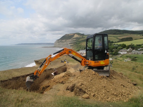
Martin cracked on with the last of the drawing and recording, Carol and Millie finished digging the eastern end. I attacked the possible second kiln/oven and finished revealing the opening of the first one. Rob and Fay went for the natural bedrock in their trenches, with help from Clive and his digger 🙂

Looking west along the trench Carol working in the eastern end and Martin recording the section


Martin recording the extra information uncovered in the eastern end of the trench

Martin recording the extra information uncovered in the eastern end of the trench


Due to the efforts of all the diggers Clive only needed to do one scoop to hit the bottom of the burnt mound material, the thin buried soil it was sat on and he top of the natural bedrock. The layer under the mound was very pale grey and silty. We took a sample of this to look for pollen and to look at the soil make up, one of many samples taken through the mound.

The small scoop taken out by the digger after Fay had cleaned it up, so we could see the layers better

The small scoop taken out by the digger after Fay had cleaned it up, so we could see the layers better

IMG_0861

The kiln/oven finally gave up its form, the charcoal spread out of the opening. The second kiln/oven had a layer of burnt clay but no charcoal under that layer, just a brown soil, but one side of the opening was very clear to see. Both had an opening facing the same way, west-south-west.

The kilns/ovens side by side

The kilns/ovens side by side

The charcoal was very well preserved as I found earlier. It’s amazing that the structure of the wood is locked by burning and we will be able to see what species it was thousands of years later.

Well preserved charcoal

Well preserved charcoal

Then the sad moment came for Clive to start filling in the trench, and time for us to eat a sandwich, re-hydrate and have some Women’s Institute lemon drizzle cake provided by Fay. Yummy!

Clive starts the back filling

Clive starts the back filling

We had one last task to do, with Clive happy to help we just dug out the area next to the kiln/oven to see if we had another one to the inland side, alas we didn’t but it was worth a look as we would always have wondered.

The last few scrapes

The last few scrapes

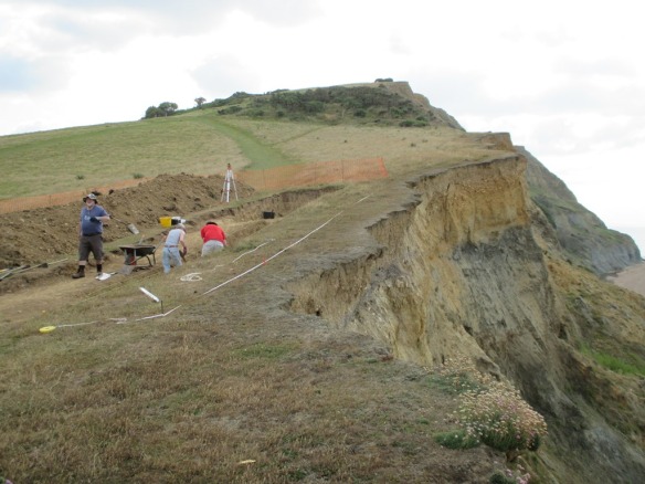
With one last look at the cliff edge that had been our ‘office’ for two weeks we headed down to pack up the tools and then for a well earned cuppa.

Martin and Rob reflecting on the last two weeks

Martin and Rob reflecting on the last two weeks

We will post updates about all the samples we took and the radiocarbon dates as we get them back from the specialists. The pottery and flints need washing before we send them for identification and dating. So keep watching the blog.

NEWS – The next dig will be Chedworth Roman Villa, from 18th August, see you there 🙂

Day eleven – it always happens…..

Sorry for the delay in updates. It seems to be the law in archaeology that features appear at the last moment, and time moves so quickly on the last few days!

We had lots of visitors today, the school came back to do some post excavation finds washing and colleagues from our team came to visit and to help. Stephen, one of our curators, was soon mattocking and Mike our gardens advisor was chief bucket emptier along with our line manager Wendy.

 Our team from the National Trust came to visit and help on site

Our team from the National Trust came to visit and help on site, Stephen wielding the mattock

Due to the time constraints it was time to reduce the trench size again and target the areas we needed answers from. The eastern end of the mound was not behaving so we need to find where it ended and if the stoney area was related to the mound or something else altogether.

Millie and Carol were giving the mission to sort out the eastern end

Millie and Carol were giving the mission to sort out the eastern end

Meanwhile down at the western end of the trench Rob was finding a ditch cutting through the end of the mound!

The ditch appearing with the black mound materiel on the right and left edge of the picture

The ditch appearing with the black mound material on the right edge of the smaller trench


Martin recording the ditch with help from Rob who dug it

Martin recording the ditch with help from Rob who dug it

The mound keeps going down, but has now got small patches of clay within it; hopefully not far to go now until we find the bottom of it.

The black mound

The black mound

This was the day the kiln/hearth/oven would reveal it’s flue/opening, or was it! As I worked to remove more of the red burnt clay (possibly the collapsed walls of the feature) I found the edge of a piece of pottery. It looked like it may be sat under a lump of clay that may have been one side of the opening of the kiln/hearth/oven.

 The edge of a  large sherd of pottery

The edge of a large sherd of pottery

As I dug it got bigger, and bigger.

The pottery got bigger!

The pottery got bigger!

Then it was time to remove the clay that seemed to be filling it.

The clay lump removed

The pottery fully exposed

Sadly it was cracked and small roots had grown through the cracks. As each piece came out we realized it was a base of a pot.

A lovely base

A lovely base

Phew! What a day. We stayed late to get as much done as we could, Martin had been recording and drawing the sections, while we all concentrated on our own small areas of the site. We left for a well-earned end of dig pizza, and a refreshing brew, hoping that in the last day we could manage to finish before Clive back-filled the site, and the porta- cabin disappeared!

Day nine – Busy, busy, busy

Martin on TV

Martin on TV

Today was a great day for many reasons. We had visits from the media, 13 students from the local school at Beaminster, and environmental archaeologist Mike Allen (Allen Environmental Archaeology) on site. The students took turns excavating, sieving the material from the mound and searching the soil heap for missed finds the digger machine had dug up.

Students  excavating on site

Students excavating on site

Sieving the mound soil

Students sieving the mound soil

Students Searching the spoil heap

Students searching the spoil heap

Mike came to site to take environmental samples and to look at the soils on site, to help tell the story of the processes of burial of our features – the burnt mound and kiln/hearth.

Mike preparing his samples

Mike preparing his samples

He took soil columns to provide uncontaminated samples. He will take smaller samples from them to look for pollen. Also Mike will look at the structure of the soils to see how they were formed, for example by down-wash of soil from cultivated land further up the hill. We will up date what Mike finds in a future post over the next few months 🙂

In the foreground one of the columns of soil wrapped in cling film

In the foreground one of the columns of soil wrapped in cling film

Martin and Rob carried on removing the orange yellow soils on the west side of the kiln/hearth, and at about 11 o clock the whoop went up as they found the burnt mound layer. Hurrah! More worked flints had been found just above the mound layer, more blades and scrapers, and pottery.

Prehistoric pottery - very crumbly!

Prehistoric pottery – very crumbly!

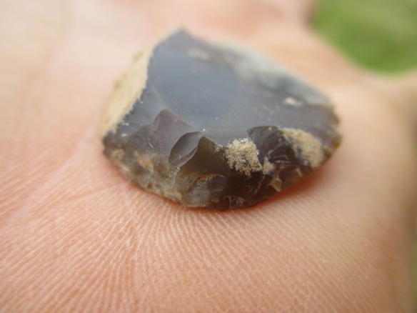
A lovely flint scraper, it could have been used for taking hair of hides or meat from bons

A lovely flint scraper, perhaps used for taking hair off hides or meat from bones

Day seven – Misty morn

Golden Cap hidden by the rain clouds

Golden Cap hidden by the rain clouds

The rain stopped play for the morning, but there is always something to do even if not on site. I had time to sort out the finds and separate the pottery from the flint. I also reorganized the tool boxes ready for the next week of digging.

On a rainy day there is always the porta-cabin to hide in

On a rainy day there is always the porta-cabin to hide in

When the rain stopped I headed up to site and was soon joined by Allan. We carried on digging out the layer on the west side of the hearth/kiln/oven feature, even though it was tempting to start to excavate the possible burnt mound layer.

Alan hunting for flint tools

Allan hunting for flint tools

We were joined by a friendly visitor for the afternoon, looking for food!

A Lesser Black-backed Gull, looking for food

A Lesser Black-backed Gull, hoping for another biscuit crumb

We found lots more flint and this time it was very good quality, including reworked tools. We also found another sherd of pottery, this time very orange with a black core, quite different to what we have found already.

A lovely long blade

A lovely long blade

The scraper

A tool called a scraper

A small sherd of pottery

A small sherd of pottery

Day Five – WOW!

The flutter of anticipation has been released into the blue sky 🙂 we have had a brilliant day, the site is blooming, struck flint and pottery coming out thick and fast! But the real star is the round yellow feature filled with deep orange with hints of black, more on this later 🙂 The picture below shows it just appearing as Martin mattocks gently the hard surface.

The feature can be seen as a red and dark brown black area next to the side of the trench

The feature can be seen as a red and dark brown black area next to the side of the trench

The pottery that is being dug up at the moment looks more like Iron Age pottery than Bronze Age. It seems a bit different to the pottery we are used to finding in Dorset and may have more in common with pottery from Devon and Cornwall. At the site we excavated just over the hill, at Dog House, we found Bronze Age pottery from near Bodmin, in Cornwall. One piece that came from the feature described earlier, was an exciting surprise, showing a deep incised decoration of hatched lines (see picture below)

The small piece of decorated pottery. We hope we will find more

The small piece of decorated pottery, hopefully we will find more

Now back to the feature, it was very dry and did not look very impressive, so it was down to the garden center to get a water spray and Tommy went off to the rangers office to get some water. It was well worth the journey through the holiday traffic, as the spray soon highlighted what could be a hearth or kiln of some kind!  It was definitely a Wow moment 🙂 The yellow is the sides or wall with orange clay in the middle and a charcoal layer just appearing lower down.

The outer yellow of the 'wall' of the hearth/kiln/fire pit

The outer yellow of the ‘wall’ of the hearth/kiln/fire pit

The feature is right in the middle of the trench

The feature is right in the middle of the trench

We said goodbye today to Ray, our barrower supreme. Thanks for staying to help, you were a valuable member of the team, especially as I am out of action due to a  dodgy shoulder.

Ray 'Mr Barrow' Lewis take a bow :-)

Ray ‘Mr Barrow’ Lewis take a bow 🙂


Day Four – and there’s more


The site looking East

The site looking East

The trench is holding on to its secrets, we are still going down, but it’s slow, exhausting work, as the ground is so hard and the weather so hot. But progress has been made by the diggers, and there has been more pottery and some lovely quality flint tools found today. The flutter of anticipation is still there and with every mattock swing we may just uncover the ashy charcoal layer filled with answers to the many questions we have about the site.

The mattock gang

The mattock gang

Today we were joined by Robin who was on his holidays but very interested in what we were doing. He came to help find any objects the diggers had missed. He set to work on the spoil heap and found a piece of prehistoric pottery and some struck flints. Sadly soon his Dad came to get him as the car was packed and they had to wend their way back home to Scotland. Hope to see you again Robin when you are older and we can come and help on a dig you are running 🙂

Robin and his Mum finding archaeological finds on the spoil heap

Robin and his Mum finding archaeological finds on the spoil heap

A very happy Robin

A very happy Robin


Possible Bronze Age pottery found today

Possible Bronze Age pottery found today