
Another trip into south-east Dorset.
The building surveyor met me in Kingston Lacy car park and drove me to 516 Little Pamphill. It was being refurbished.

516 Little Pamphill, the original thatched cob cottage is on the left. Gable end to the road behind the hedge.
The best and original part was beside the lane. This was a ‘cob’ building built with local earth, some straw and other bits and pieces thrown in and packed between wood shuttering. Once dried and set, the shuttering was taken away and the building was roofed and thatched.
Interesting…..516 had a cob chimney, capped off with three courses of brick.

The cob chimney and to the right the junction of the cob wall with the early 20th century brick extension.
A light was shone through a small hatch to reveal that the thatched roof was supported by cut poles of ash. Grown locally and coppiced when grown to the right size. Not a sophisticated building. A small cottage thrown up about 250 years ago. The historic building survey described it as a ‘squatter’s cottage’

A well preserved roof made of rough cut ash poles. Looks unchanged since 18th century which is an unusual survival for such a low status cottage if true.
A brick extension was added about 100 years ago and later still an annexe and a breeze block bathroom.
The cob chimney and ash pole roof were the best bits and would be cared for during the refurbishment..any other significant features had been modernised away before the NT acquired the place in the 1980s.
But! there was an open service trench, dug to take a gas supply pipe.. Leading from the back door for 30m.
That’s what archaeologists do…. they mostly look at holes in the ground.
I had some time…so I followed it, just to see if any secrets might be revealed. For the first 15 paces the soil was dark and mixed. Organic dug garden soil, a local sandy loam mixed with fragments of white and blue 19th-20th century pottery and the usual random black flake of prehistoric flint. Just grass now but this had been a vegetable garden once.

The trench soil changes from dark garden material to stony building debris. Greensand foundation stone middle left.
Then, as the trench passed behind the building contractor’s portacabin, the spoil heap changed to orange brown clay and heaps of rubble..sandstone, brick and lumps of flint. I jumped down into the trench where the change took place.
The garden soil was heaped against the remains of a stone wall and in the bottom of the trench, a large foundation block of greensand. Beyond this, looking into the cut sides of the trench section… there was a jumbled sea of building debris mixed with lime mortar and the same orangy earth similar to that which had been used for the cob of 516.
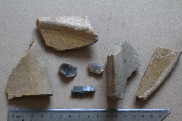
The 17th-18th century pottery from the building rubble and a few random prehistoric flints.
I pulled out 4 pieces of earthenware pot, all with the same yellow mustard glaze. A mixing bowl, a jar, a dish and a plate. 17th-18th century. Nothing very modern in the jumble.
Martin had finished his meeting with the structural engineer. There’s a nasty crack in the cob that needs some remedial work. I got a lift back to my car and drove back to the office to look at the maps.
Let’s go back in time. Always good to start with the Ordnance Survey 25 inch to the mile maps. The 1924 edition shows the plan of 516 much as it is today. The 1901 map just shows the old cob part .. as does the 1888 first edition. Nothing to give a clue that there had been another cottage nearby.
OK, so lets look at the Wimborne Minster tithe map surveyed in 1846. 516 is clear but nothing else.

A tracing of the 1846 tithe map. 516 is on the left side of plot 2198 but nothing in plot 2199 where the trench revealed rubble. The names in red are the tenants in 1773 and in black those of 1846.
There was one more option. William Woodward’s survey of Kingston Lacy commissioned by the then owner Henry Bankes in 1773.

Woodward’s survey of 1773 and 516 is shown in plot 52 but look in plot 53. There are two buildings still standing at this time.
Jackpot! There was my building standing just where the trench had passed through and with a second building a little to the south.

Woodward’s record of who rented each plot. Plot 52 (516) was leased to William Cox but either William Eaton or Margaret Lawrence had the copyhold tenancy of plot 53. In brackets are the older lease and copy names that can be traced back to the 1591 survey of the manor.
A smallholding it seems but why was it demolished? Woodward gives a clue.. he was unsure who the tenant was.. perhaps it was abandoned by this time, fell into disrepair and was knocked down. By 1846, it was part of someone else’s tenancy. Forgotten until I bumped into it again last week.
